Just to note that yes, I covered this, by public transport and some hiking, during one hot day – so the beach and swim proved very welcome; and by the end of the day I was well tired!
Shek O: Pure Morning
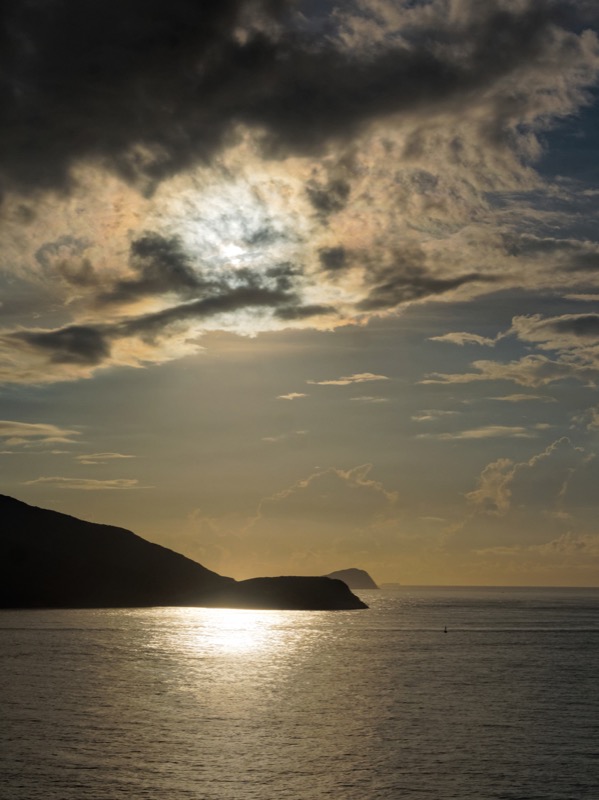
Early on a clear summer morning, from a vantage atop Tai Tau Chau – an islet by Shek O, you can fully appreciate Hong Kong’s superb location on the south China coast. To the east, the rising sun casts a golden glow silhouetting the tip of Tung Lung Chau. South lies craggy Waglan Island, which you mostly hear of in weather reports when typhoons approach.
Viewed from here, the coast of Hong Kong Island is backed by steep green hillsides; a lighthouse is just visible at Cape D’Aguilar, the southeastern headland, beyond which are Beaufort Island, Po Toi and the Dangan Islands. The only high rises in view seem far off, in Tseung Kwan O. With its hotchpotch of mostly two and three storey buildings, Shek O looks almost like a Mediterranean village.
While great for admiring scenery, Tai Tau Chau has little but windswept trees and bushes, a pavilion and a barbecue site by the cliffs. So no more lingering here. It’s time to move off, and explore more of the wilder side of Hong Kong Island.
There’s a path down, then a footbridge to the Shek O headland that’s topped by a cluster of expensive looking buildings behind walls and sturdy gates; one has architecture recalling Beijing’s Forbidden City. Just inland is the old village, with older, tightly packed houses. Barn swallows swoop after insects, adding to the rural atmosphere and surely nesting close by.
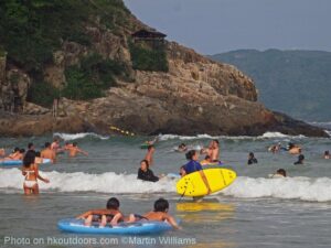
Only a handful of swimmers and strollers are on the beach – one of the best in Hong Kong. Most small shops and restaurants are still shuttered. A handful of people wait by the splendid old bus terminus, and a minibus arrives, to take passengers up and over the hills, towards the metropolis.
Getting there
From just outside Shau Kei Wan MTR station you can take bus 9 or a red minibus.
Tai Tam Tuk: Temporary Torrent
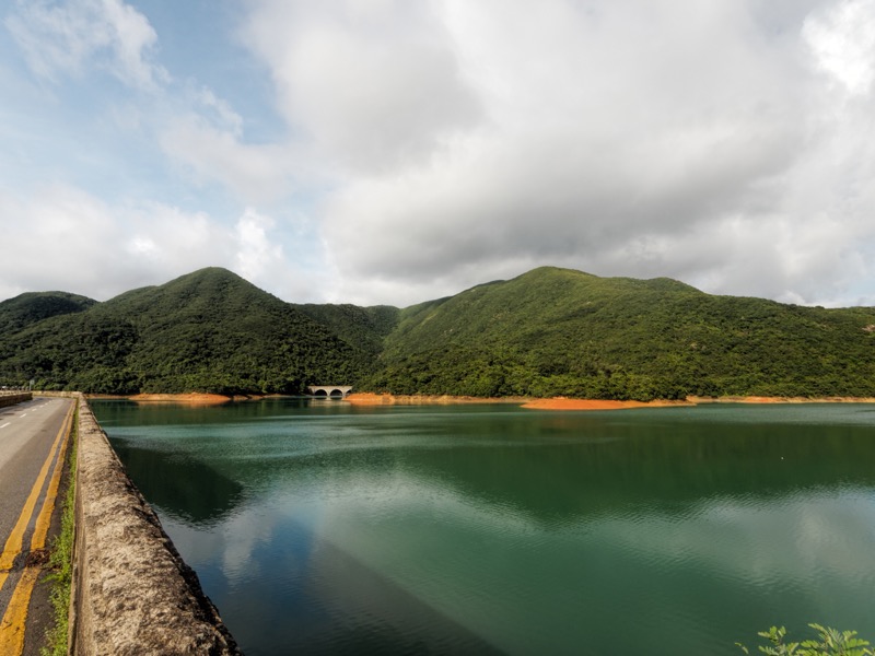
But you can also travel up, round, and down to Tai Tam Tuk, the innermost area of the inlet between Cape D’Aguilar and Stanley peninsulas. Just above it, the largest reservoir on the island is set amidst wooded hills. Buses, taxis and even supercars slow to a crawl on the road across the mighty dam – not because drivers are admiring the view, but as there’s barely enough room for two lane traffic.
Stage 7 of the Hong Kong Trail starts here, leading down to a water catchment channel, then following this southwards above Tai Tam Harbour. On this morning, two metal sluice gates – embossed with the maker’s name, Ransomes & Rapier Ltd (Ipswich, England) are diverting the flow to a side channel, where a roaring torrent pours down towards the sea.

A narrow trail drops through the woods, to the edge of the inlet, and a jungle-style path above the last mangrove forest on Hong Kong Island. Crabs scuttle for cover, gaps in the foliage afford glimpses of the shore with small boats moored close by, a simple looking hamlet next to the water, school buildings rising beyond.
The path reaches a stream swollen with the diverted flow, its waters foaming down a cascade sliced through granite. Normally, it must be easy to cross, leading around towards an eco education centre. But now, it’s a dead end, so back up the slope, to cross a road and walk on Stage 6 of the Hong Kong Trail.
Getting there
Bus 14 from Chai Wan (via Shau Kei Wan, and Shek O Roundabout).
Tai Tam Country Park: Valley of the Dammed
With the blazing sun now high overhead, there’s welcome shade as the trail tunnels through dense woodland that clothe the hillsides of Tai Tam Country Park – and help moderate water flows to the three reservoirs here.
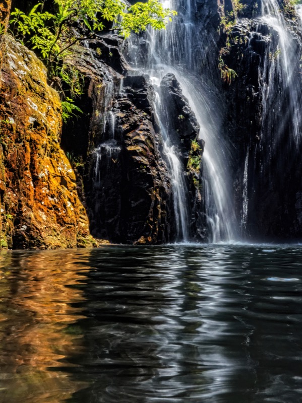
As it’s rainy season, a side trip to Tai Tam Mound Waterfall seems essential. There’s no sign to the fall; just arrive at the third footbridge from Tai Tam Road – the one with slender wooden planks – and scramble down a tiny stream channel. It’s a beautiful waterfall, and the shady plunge pool offers welcome respite from the heat.
The trail meets a narrow road thats off limits to most vehicles. Choices for hiking and strolling abound, in a wonderful landscape of rolling hills, streams, forest and reservoirs. They include the Tai Tam Waterworks Heritage Trail, which covers dams, aqueducts, bridges and other structures that date from the late 19th and early 20th century. There are uphill routes, like the Hong Kong Trail climbing to Mount Butler, with fabulous views from the top. But these don’t appeal on a day when the weather dial’s stuck on Scorchio!
An easy walk passes the west shore of Tai Tam Tuk Reservoir. It’s a well travelled route, and another trail towards Repulse Bay seems more enticing. There’s a chance to gaze at the dam of Tai Tam Intermediate Reservoir, which was completed in 1907. Then a path by the reservoir’s southern shore, and up to a pass, Tsin Shui Wan Au. On a map, short trails from here to Repulse Bay look appealing, yet a sign beside one warns it’s “treacherous”, another is overgrown, with big Golden Orb Weaver spiders suspended from a succession of webs at waist height.
So, the simplest “escape” route seems to be alongside a catchment, hugging a steep hillside and aiming for Stanley, before a flight of steps to the road below.
Phew! – it’s time to go and cool down someplace, like a beach.
Getting there
Bus 14 from Chai Wan (via Shau Kei Wan, and Shek O Roundabout).
Chung Hom Kok Beach: There’s Nothing There
The map indicates Chung Hom Kok Beach could be worth a try. It’s below a headland west of Stanley that’s shown as intense green – a nature park, free of housing or other developments.
A taxi seems the best way of getting there swiftly, though the driver is hardly encouraging when told the destination. “There’s nothing there,” he says. “Maybe you can try Stanley Plaza.”
Ah, a shopping mall, with air conditioning, jam packed with places to spend, spend, spend. While very Hong Kong style, that would hardly please the editor awaiting a tale of wild Hong Kong Island, so Chung Hom Kok Beach it is then, to investigate nothing.
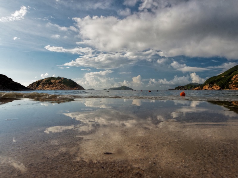
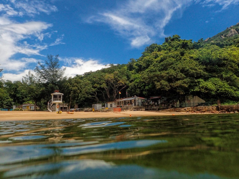
There’s still some more hiking required, down steps and past a large children’s playground, before arriving at the beach, which proves to be a wonderful stretch of sand in a small bay set between steep bluffs. While there are some houses above, the setting is mostly green, with fine trees behind the lifeguards’ place, and views across to Ocean Park, Lamma, and Lantau hills.
Maybe Repulse Bay is crowded today, yet here there are less then ten other visitors (so if you ever know any crowds in search of a beach – send them to Repulse Bay, not here). The relatively clean water is splendidly refreshing after the steamy outing so far.
Getting there
Options include minibus 40 from Causeway Bay.
High West: Here’s to the Crazy Ones
Onwards and westwards!
And upwards, via Victoria Peak. The Upper Peak Tram area is hardly wild, yet a short walk along Lugard Road is enough to leave most tourists behind, with woodland and shrubland alongside, views over the city and Victoria Harbour below.
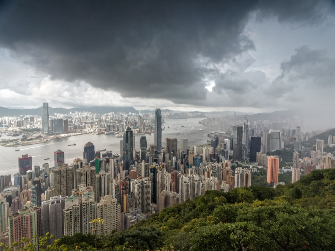
A sudden rainstorm arrives, dark clouds rolling in over the skyscrapers. Thunder booms and lightning flashes. The scene suddenly recalls the first Independence Day – a reminder that even urban Hong Kong is in a wild part of the world.
At the end of Lugard Road is a small park, from where a path leads towards what may be the wildest summit on Hong Kong Island: High West. It’s a good trail, though somewhat tough with steep steps up, up and up to the top. The start of it would be easy to miss, and I don’t notice any signs – as if there’s no attempt to encourage any regular visitors, but instead leave this peak to anyone feeling a little wild, even crazy.
Which on this sultry summer afternoon means only me, for most of the time. Though a guy wearing running gear and a baseball cap jogs up to the top, seemingly wishes there was still a thunderstorm as he remarks, “It’s not nearly as moody as it was half an hour ago,” and promptly turns and jogs off back the way he came.
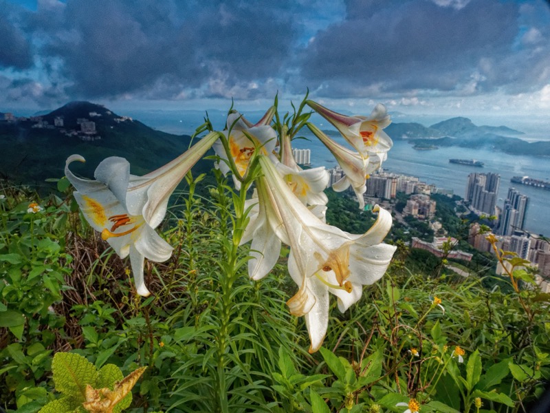
This is an outstanding viewpoint. Not so much for admirers of the city – which is partly hidden by the Peak, but more for appreciating hills to the north, Lantau dominating the western horizon, and Lamma across the channel from Pokfulam. As the sun dips lower, becomes less fierce, it illuminates a billowing cloud above the far horizon that looks the sort of place a god lives.
Right, that’s enough scenery for today [and, I did cover all in a day; bloody tired afterwards!]. After the steps down, Harlech Road offers a shorter route back to the Peak Tram station, with only a brief stop for photos of the small but picturesque waterfall. Time to leave the wild side, and embark on a crucial new quest – the search for cold beer.
Getting there
While the Peak Tram is fun, you might avoid queuing by taking a bus such as No 15 from the Central Ferry Piers.