
 Hong Kong can be impacted by tropical cyclones including and typhoons.
Happily, typhoons are scarce near Hong Kong, and rarely score direct hits (13 from 1946 to now) – but can be spectacular and deadly when they do impact the territory.
As they need warm sea water to spawn and grow, tropical storms are rare in winter, mainly occurring from around May to October – with Hong Kong mostly affected from mid-August to early October.
The storms begin quietly at first, as a region of still air over the warm sea gives rise to a cluster of thunderstorms; rain falls, cooling the air and so reducing pressure. The surrounding air pressure increases, warming the air, which rises, cools to yield more rain, so helping build the process. The system starts to spin, counter-clockwise, and if conditions are just right – for all their ferocity, these storms need things just right if they aren’t to weaken or fizzle out – the wind around the low keeps building. (I’ve nabbed this info from NASA, which has a longer, better explanation at Hurricanes: the Greatest Storms on Earth).
At such times, we may hear on weather forecasts something like “a Tropical Depression appears to be forming over the sea east of the Philippines”. If the mean maximum wind speed in ten-minute intervals (or one-minute intervals if US based, like the Joint Typhoon Warning Center) exceeds 37 km (23 miles) per hour, a Tropical Depression has indeed formed.
The tropical depressions don’t seem to do much except sit around and, if conditions remain good, intensify further, with the pressure still falling, winds building.
Tropical storms are next in the tropical cyclone progression, with mean winds of at least 63km (39 miles) per hour. These are still relatively weak, albeit if you were affected by the middle of one you might find it real blustery and windy, but they can become stronger; sometimes, they intensify rapidly.
A typhoon starts heading for Hong Kong
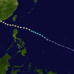
Once the cyclones have become organised into tropical storms, it seems they start moving; those forming in the west Pacific (for tropical cyclones, this includes the South China Sea) tend to move west, and north – maybe later curling northeast if they survive. But they do so quirkily, sometimes moving purposefully, sometimes erratically, and at varying speeds. Much computing is done nowadays, with plenty of data input, yet these storms are still far from fully predictable.
Now, if all is right (no wind shear, a good supply of warm sea water below), the moving storm can keep on growing. When the mean winds exceed 88km per hour, it’s a severe tropical storm – not something you’d want to mess with at the centre.
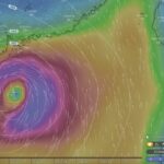
Then, as the storm tightens further, the mean winds at the centre may pass 118 km (74 miles) per hour, with far stronger gusts. Some of the rising air from around the typhoon is drawn to the low pressure centre; because this air has lost most of its its moisture, the air here is relatively dry, and there may be only thin clouds or even clear sky. This is the eye of the storm.
The most powerful winds rage around the eye, in the eye wall; out beyond them is cloud, and rain, which is densest in spiral bands that may contain countless thunderstorms. (The NASA page notes that, “during its life cycle a hurricane can expend as much energy as 10,000 nuclear bombs!”)
Typhoons can strengthen still further, perhaps even becoming “super typhoons” (seems to be a more US definition; maximum sustained surface winds, over one-minute average, of 240km (150 mies) per hour). The Saffir-Simpson scale for hurricane intensities hasn’t been (widely) adopted for typhoons, but on this scale, a regular typhoon ranks 1-3 (or 4), and a super typhoon 4 or 5. (See this page for the scale adapted for typhoons.)
Hong Kong’s typhoon warning signals
As a tropical storm or typhoon comes closer to Hong Kong, the Observatory issues warning signals. The Number One is just an alert, to say a tropical storm is within 800km of Hong Kong and may affect the territory. Not much to worry about in near term; indeed, the weather in Hong Kong may be hot (even stifling) and sunny.
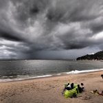
Then, there’s the Number 3 strong wind signal – winds with a mean wind speed of 41-62 km per hour are expected or already blowing in Victoria Harbour. It’s blustery, maybe there’s some heavy rain, but no big deal. Surfers might head to beaches like Big Wave Bay on Hong Kong Island; birders might be out and about too, watching for seabirds blown inshore (though it appears the chances are higher with more powerful winds).
The next signal is the Number 8, much beloved by office workers – as offices generally close once the Number 8 is up (that doesn’t always seem necessary, but there we are: see this discussion, with detailed response from K.H. Cheung of the Hong Kong Observatory). This says gale or storm force winds – sustained speed of 63-117 km per hour – are imminent or blowing in Victoria Harbour. Conditions become more “exciting”, with news reports perhaps showing reporters out by the harbourside, maybe wearing safety helmets as they shout over the noise of the rain, over footage showing people with umbrellas blown inside out, driving rain and choppy seas by ferry piers. (Or, sometimes, there isn’t much happening at all; the gales may take time coming, or may be a bit wimpy.)
Often, that’s about it; the Number 8 may be up for a while, or may not be issued at all – even with strong typhoons, you have to be close to the centre to experience the real power; a hundred or more so kilometres away, and they’re just big storm systems, albeit perhaps spawning squally thunderstorms.
But, occasionally, the 8 is followed by the Number 9: gale or storm force winds blowing in the harbour are increasing or expected to significantly increase. The storm looks set to make a direct hit on Hong Kong – and will do so within hours! Pretty much everything that wasn’t closed already now shuts; streets are pretty much deserted, though in sheltered areas there may be still some people wandering about, and some taxis might still operate, usually for hefty prices.
Direct hit by a typhoon – and the eye of the storm
Then, there’s Hong Kong’s ultimate weather signal: the Number 10. Hurricane force winds are blowing or expected in the harbour. A typhoon is scoring a direct hit on the territory.
Massive winds, roaring like express trains, are blowing; there are probably severe downpours. Yet, in sheltered places, all can seem fairly tranquil.
Indeed, winds can drop quickly, and the sky lightens, maybe with storm clouds yielding to blue sky, if the eye passes overhead. This calm may last minutes, or hours, but it ends just as quickly as the winds again scream to hurricane force, and the typhoon again batters Hong Kong – as the wind direction changes around the eye, it may now slam places that were sheltered.
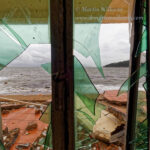
During a Number 10, Hong Kong is essentially closed. But, surfers might be unwilling to leave beaches with huge swells, birders may stubbornly remain on exposed headlands, lusting after rare seabirds that might have been blasted nearby. Some people hold typhoon parties, with booze and music helping make a storm a fun event. For others, however, a typhoon can be hazardous, even life threatening; they might be impacted by flooding, by winds that threaten to rip their homes apart, or even by a storm surge: see next article, Hong Kong typhoons.
Fewer South China Sea Typhoons
Perhaps oddly given global warming, there has been a recent, significant decline in the numbers of typhoons entering the South China Sea. This might be linked to warmer South China Sea temperatures, in turn influencing the ways tropical storms are steered and causing a higher proportion of storms forming over the west Pacific to head towards Japan or east China. For more info, see a paper from 2007 (pdf): Recent decline in typhoon activity in the South China Sea.
Tropical Storm Websites
There are several good tropical storm websites. The Hong Kong Observatory is an important site when a storm may impact Hong Kong (try real time satellite images and, if a storm is close, check out the radar images); Weather Underground of Hong Kong is good – though no longer with active forums; and the Joint Typhoon Warning Center has info including forecast strengths and tracks that may differ somewhat from the Observatory’s forecasts. CIMSS Tropical Cyclones is also worth checking; also includes tropical storms elsewhere, including Atlantic hurricanes; maps of forecast tracks are coloured to indicate actual/forecast storm strengths. Tropical Cyclone Intensity and Track Forecasts, from MIT, has charts and maps with data from several predictive models.
Windy.com is a top site to check for forecasts by computer models, including ECMWF and GFS. The smartphone app is well worth getting.
Weather including tropical cyclones
Tropical Cyclone Ma-on Headed for Hong Kong
25 August 2022 (evening) update: Ma-on took a track somewhat south and west of earlier forecasts;…
Severe Typhoon Mangkhut highlights perils of massive reclamation by Lantau
Typhoon Mangkhut helped show “storm surge” is a threat to modern cities, not just something for…

Typhoon Jebi a Warning for East Lantau Metropolis aka Lantau Tomorrow Vision
You may have seen the shocking images from Japan in September 2018, including as Osaka’s Kansai…
Mad Lantau Metropolis Plans Should be Scuppered by Storm Surge Threat
A consideration of science suggests the reclamation plans, including for East Lantau Metropolis are foolhardy, even…
As Hong Kong Sizzles the World Keeps Warming
While climate change may have long seemed an issue for hardcore, tree-hugging environmentalists, concerns are spreading.…
Typhoon Haiyan Lessons for Hong Kong
Typhoon Haiyan was among the strongest storms on record, and devastated a swathe of the Philippines.…

Forecasters Benefit from Flights into Typhoons
As well as employing computer models and weather station info, the Hong Kong Observatory is employing…
Hong Kong weather outlook warmer wetter wilder
With global warming only just getting started, according to scientists, it’s time for Hong Kong to…
Typhoon Vicente hurricane force winds blast Hong Kong
Severe Typhoon Vicente slammed Hong Kong on 23 and 24 July 2012, with hurricane force winds…

Severe Tropical Storm Pabuk
Severe Tropical Storm Pabuk looked set to have passed Hong Kong, barely causing an impact other…
HK Number 8 Signal
Hong Kong’s Number 8 tropical cyclone warning can be controversial. Hong Kong’s Number 8 tropical cyclone…
Hong Kong Typhoons including Calamitous Storm Surges
Typhoons have sometimes caused massive damage and loss of life in Hong Kong. Just months after…