
Typhoons have sometimes caused massive damage and loss of life in Hong Kong.
Just months after British sovereignty over Hong Kong Island was first declared in 1841, “a violent typhoon flattened all the insubstantial housing and damaged shipping.” (Endacott, A History of Hong Kong.) (For a little info on how typhoons form, and Hong Kong’s typhoon signals, see my article Hong Kong tropical cyclones.)
The 1874 Typhoon: devastation of Pearl River Delta including Hong Kong
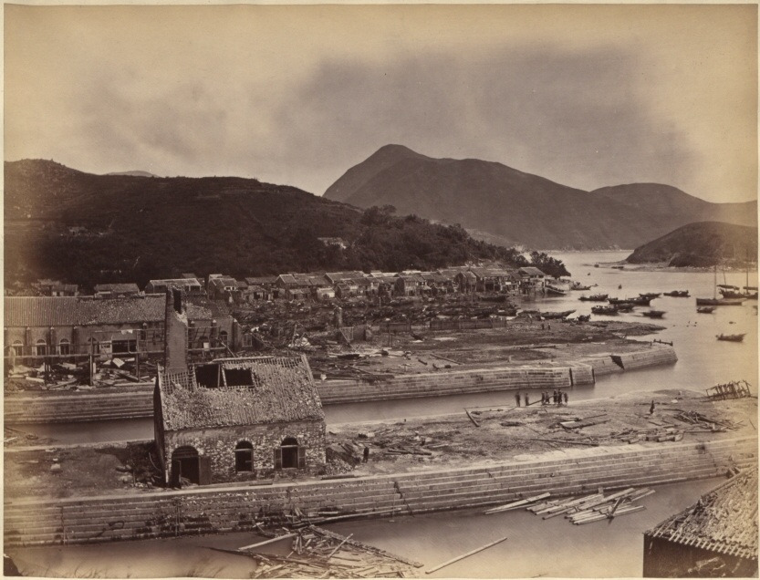
One of Hong Kong’s worst typhoons struck in 1874; according to an eyewitness, Eitel, in Europe in China (1895):
“the town looked as if it had undergone a terrific bombardment. Rows of houses were unroofed, hundreds of European and Chinese dwellings were in ruins, large trees were torn out by their roots … in every direction dead bodies were seen floating about or scattered among the ruins … thirty-five foreign vessels, trusting in their anchors, were wrecked or badly injured.”
Welsh, A History of Hong Kong.
The typhoon made news around the world – but not instantly as today. According to one account:
The Praya [former waterfront promenade; Des Voeux Road is now along at least part of the Praya] is demolished, the embankment having been washed away so far as to undermine the fronts of many of the buildings, the face walls of which fell ; and the waves washed up to within a few feet of the Queen’s Road.
The Straits Times, 3 October 1874
An account in the Hong Kong Press later appeared in the New York Times; it included:
The barometer kept rapidly falling, and the wind increased frightfully in violence, raging and howling at first, and after a time sounding like one continued peal of musketry, breken at intervals by artillery, as sudden and. more violent gusts swept through the harbor and over the lanes At times, even above the fierce bowling of the wind could be heard the pitiful cries or thousands vainly battling with the storm. Not a single ship in port escaped undamaged, and the casual ties and loss of life—the latter estimated at over 2,000 souls, have exceeded anything which has ever before been upon record.
The city, after the occurrence, presented the appearance of a town ‘which had been besieged. In all directions were roofless and shattered houses, crambling walls, naked poles and rafters standing out gloomily against the leaden sky. The roadswere strewn right and left with debris, wreck of boats and trees, some of gigantic size, torn up by the roots. The telegraph on the island, and the marine telegraph between Hong Kong, and Saigon wore interrupted, the gas-pipes were torn rip, dead bodies in all directions washed ashore.
The tide was exceptionally high, and to the eastward a great deal of injury both to life and property was caused by the height of the water, which on the plain at East Point was, on an average, about four feet high.
Typhoon at Hong Kong: Great Destruction of Life and Property
This article included an eyewitness account:
“I had been out dining with a friend and started to return home at a little after 11. It was then blowing very hard. but neither I nor any of my companion had any idea of the severity to which the gale was destined to reach. I accordingly went with a companion to the Prays to see the sight, and certainly never witnessed anything so striking in my life. Although I have seen many typhoons during a stay of over fourteen years in Hong Kong, I do not know of any which has caused so much injury to the colony and so much loss of life. By the time we arrived at the Praya, the wind had freshened rapidly, and the typhoon was raging with full vigor. The sea was breaking over the Praya with terrific force, while the roar was deafening.
“The waves broke briefly, with phosphoresent light, and presented a striking and awful sight_ The lights on shore flickered through the darkness and seemed only to render it the more intense. Gradually the swell increased and the waves rushed first half across the Praya snd afterward quite across it, and before I had reached Pustan’s wharf, towards I was going westward, they were more than acros the Praya, and I had to push my way knee-deep in water. Clinging to such projections from the houses as were within my reach I endeavored to continue on my course, but soon found that it was too dangerous to persevere as the waves were coming in with such force that there was every chance of being washed away, while tiles and bricks were falling in all directions from the shaken housees. It was 1 o’clock when I was thus forced to beat a retreat, and I may mention that up to that time none of the sad casualties which have been recorded had occurred; and as the gale began to moderate by 3 o’clock, it is evident that the havec must have been the work of little more than two hours.”
There was no proper death toll; perhaps 2000-10,000 people were killed in Hong Kong; this storm helped spur the establishment of Hong Kong Observatory.
The typhoon also caused major damage and deaths elsewhere in the Pearl River area:
The AD 1874 typhoon caused sea level to rise by ca. 5 m, the flooding of 10 counties covering about 20,000 km2 and a death toll of ca. 10,000.
RECONSTRUCTION OF AN 8,000-YEAR RECORD OF TYPHOONS IN THE PEARL RIVER ESTUARY, CHINA
Macau was devastated by the typhoon, with around 5000 people killed; as noted in a recent paper that drew on various sources to analyse the storm. This indicated that the storm had arrived from the east, probably after passing through the strait between Luzon and Taiwan – a typical track for the most severe typhoons impacting Hong Kong. Also:
The results show that both the maximum storm tide (4.88 m above Hong Kong Chart Datum) and maximum storm surge (2.83 m) brought by Typhoon 1874 at the Victoria Harbour in Hong Kong are higher than all the existing records since the establishment of the Hong Kong Observatory in 1883.
Reconstruction of the track and a simulation of the storm surge associated with the calamitous typhoon affecting the Pearl River Estuary in September 1874
1906 Typhoon
Another typhoon, also bringing a major storm surge, struck on September 1906, killing 10,000 or more people (a Wikipedia entry gives 15,000), many of them fishermen.
A book on the storm – sadly not readily available – begins:
ON the morning of the 18th September, 1906, Hongkong was visited by a typhoon which, though of short duration, proved to be the most appallingly destructive visitation of the kind that the Colony has ever experienced, not forgetting the historic typhoons of 1844 and 1874.
In the space of two hours enormous damage was done to shipping craft as well as to property ashore, while the number of lives lost in the waters of the Colony will probably never be known. Estimates range from 4,000 to 10,000. The enormous extent of the losses, both to, life and property, is attributable to the fact that, according to the Report of the Meteorological
Observatory, this typhoon ” gave no indication of its existence until close to the Colony,” and consequently no adequate warning of its approach was given by the Observatory.
The Calamitous Typhoon at Hong Kong
For info on this and other major typhoons hitting HK, see “Typhoons affecting Hong Kong: case studies” (pdf file).
The Deadly Hong Kong Typhoon of 1937
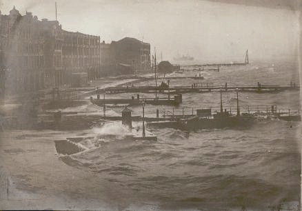
Another deadly Hong Kong typhoon slammed the then-colony on 2 September 1937, with the roaring winds pushing a great tidal surge that funnelled up Tolo Harbour, and swamped villages. With the surge arriving in darkness, many people were hit whilst they were sleeping. Perhaps 11,000 people died.
“At the time, Hong Kong harbor was the seventh busiest port in the world. During the height of the typhoon the sea level in the harbor rose about 1.8 m (6 ft) above the predicted level of high tide.”
1937- Great Hong Kong Typhoon
For photos taken in the aftermath of this 1937 typhoon, mainly of ships blasted aground (with an initial shot with some of the ships on a tranquil day before the storm), see The Great Hong Kong Typhoon – 1937; also try video on British Film Institute website: Typhoon Hong Kong September 1937 [restricted to viewing in UK; a VPN may help…]. The Great Hong Kong Typhoon article mentions the tidal surge, which also impacted Victoria Harbour, with the water reaching Des Voeux Road – and says the wind was so strong that small fish were blown, “many yards from the sea on to buildings 90ft above the ground.”
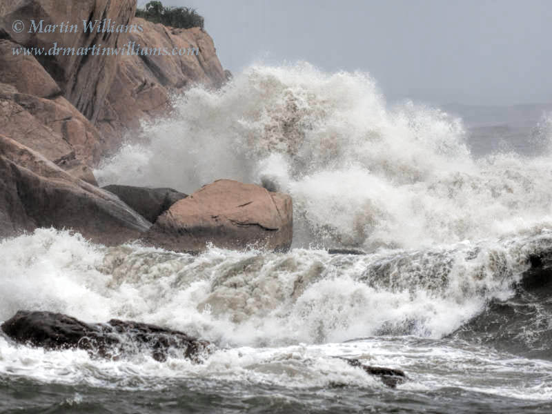
Typhoon Wanda: most powerful Hong Kong typhoon recorded
Hong Kong’s most powerful typhoon on record [given records were sparse for 1874], Wanda, also pushed a tidal wave through Tolo Harbour, but this time residents were forewarned, and though properties were wrecked there was far less loss of life, with 127 fatalities in all. Its arrival on the morning of 1 September 1962 coincided with the forecast 7-foot high tide, and in Tolo Harbour the water level was around ten feet higher than this forecast height, with wind-driven waves pushing the water level another six feet higher (to around 23 feet above “chart datum”) near Sha Tin. The high water mark reached landmarks including Sha Tin railway station – where the water was over the track but below the platform.
About a fifth of the residential huts at Sha Tin were destroyed during Typhoon Wanda, mainly by logs or boats crashing into them. Part of the seawall at Sha Tin collapsed. Fields were inundated with salt water. Damage was widespread, with 72,000 people made homeless; of 132 ocean-going ships, 24 were beached and 12 involved in collisions; many trees were uprooted or snapped off, and even among those that survived, many were stripped of leaves. (I’ve drawn this info from Typhoon Wanda on the Observatory site.)
The maximum 10-minute mean wind speed recorded at the Observatory during Typhoon Wanda was 78 kots (144km [90 miles] per hour), and the maximum gust 140 knots (259km [161 miles] per hour); a maximum gust of 284km (176 miles) per hour was recorded at Tate’s Cairn, on the hills above Kowloon.
Wanda arrived during a relatively busy spell for typhoons hitting Hong Kong – the Number 10, hurricane-force wind signal was raised five times during the early 1960s, but only on six occasions since, with only one direct hit by a typhoon in each of the 1980s and 1990s.
Typhoon York
Trees on north Cheung Chau, lashed by hurricane force winds during Typhoon York
Though I’ve been here since 1987, until 2012 I’d only experienced two direct hits by typhoons – York, in mid-September 1999; and Nuri, in August 2008 (albeit Nuri had weakened to around severe tropical storm as it hit, though winds exceeded hurricane force at Waglan Island).
York tracked relatively slowly across southern Hong Kong, forcing the Number 10 signal to stay up for a record 10 hours. The maximum gust was 234km per hour, at Waglan Island – the strongest gust Waglan has yet recorded. (Waglan also recorded the maximum hourly wind, 151km per hour.)
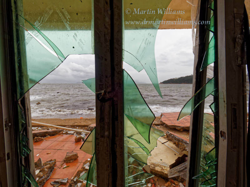
Though there was one fatality – a windsurfer who went out during the eye, Typhoon York caused relatively little damage: windows were blown out of buildings in Wanchai, fields were flooded, the container port operations severely disrupted.
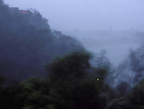
During Typhoon York, I mainly stayed at my home on Cheung Chau, which offers a fine – though exposed – vantage over the sea to the west. As York approached, I was sheltered from the winds, which roared over the hills and trees behind my place. When the winds were strongest, the air was strewn with leaves ripped from the trees. (The island’s weather station recorded gusts of up to 182km per hour.) It rained, too, with downpours so severe visibility was cut to maybe a hundred metres; the clouds were so thick it was gloomy, street lights were on even mid-morning.
There were non-stop radio reports, mentioning that the eye was passing over southern Hong Kong and, sure enough, the winds moderated, eased, the rain stopped, and the sky brightened. It had been extremely dark under thick storm clouds, but now (late morning) it was like early morning – some birds called and sang. The air was filled with dragonflies – there must have been many thousands of them, surely swept into the storm and carried with it.
During the eye, with the rain over, I had chance to scan for seabirds, but there were only a few Bridled Terns. I went for a short walk; reaching the other side of the hill, facing east, it looked like a dark grey to black wall was in front of Hong Kong Island. This was surely the eye wall, and it looked pretty close, so I headed back home.
Soon, the wind was building again. From breeze, to wind, to strong wind, then hurricane again – I reckoned it took maybe half an hour or so for the full strength winds to return. But the winds had swung, and in anticipation of this I now had typhoon shutters up over the main window (and a kitchen window away from the wind partly open – I’ve heard this can help stop air pressure fluctuating in buildings [air condistioners can get tossed into rooms, windows may be blown out, simply by changing pressure]).
I then lived in an apartment that faced Lantau, which was little more than a stone’s throw away. So, it was odd to hear someone phone in to the radio saying he was on Lantau, and the air was calm; I called in to say the wind would soon strengthen, as the eye wall returned.
Typhoon Nuri
I took some photos and video footage on this site, including within the eye, during Typhoon Nuri; “only” a tropical storm as it hit Hong Kong, though still caused some damage. And, there was calm here as the eye passed over, as in video I shot:
Typhoon Vicente, August 2012
In August 2012, a near miss by Typhoon Vicente led to Number 10 signal being issued for the first time since Typhoon York:
Super Typhoon Hato, August 2017
Hato ranked as the first super typhoon to necessitate the issuance of the Typhoon 8 signal since Hope in 1979, according to Super Typhoon Hato account by Hong Kong Observatory. It passed to the southwest of Hong Kong, bringing a storm surge that was especially severe in Macau.
Super Typhoon Mangkhut, September 2018
Mangkut became a Super Typhoon over the west Pacific; lost a little power as it just hit tip of north Luzon, but was still powerful as the eye passed Hong Kong – with intense winds even away from the centre, causing a destructive storm surge in parts of Hong Kong. Videos included waves smashing into apartment buildings in Heng Fa Chuen, Hong Kong Island – helping make this the most memorable typhoon for most Hong Kong people [many of whom were born after or too young to remember Wanda].
Here’s a video I shot as Typhoon Mangkhut approached and hit Cheung Chau, along with the aftermath on Cheung Chau:


Further Info
There are several good typhoon-related websites. The Hong Kong Observatory is an important site when a storm may impact Hong Kong (try real time satellite images and, if a storm is close, check out the radar images); Weather Underground of Hong Kong is good – forums can have much discussion of tropical storm as they form and approach; and the Joint Typhoon Warning Center has abundant info, including forecast strengths and tracks that may differ somewhat from the Observatory’s forecasts. CIMSS Tropical Cyclones is also worth checking; also includes tropical storms elsewhere, including Atlantic hurricanes; maps of forecast tracks are coloured to indicate actual/forecast storm strengths. Tropical Cyclone Intensity and Track Forecasts, from MIT, has charts and maps with data from several models.
Also, see a 2007 paper (pdf) – Recent decline in typhoon activity in the South China Sea. This reveals a significant decline in numbers of typhoons entering the South China Sea; during 1996-2005, typhoons forming over west Pacific showed more tendency to head for Japan and east China than during 1961-1995. Cause may be associated with change in ways tropical storms are steered, in turn perhaps linked to higher temperatures in the South China Sea. [Might wonder, then: will these higher temperatures lead to more typhoon formation within the S China Sea?]
Weather including tropical cyclones

Rare November Tropical Cyclones Including Typhoons in Hong Kong
As I write on 13 November 2024, Tropical Cyclone Toraji is set to pass over Hong…

Typhoons and Rainstorms Past Help Hong Kong Forecasts Today
Wetter, Wilder Weather Events Loom with Warming World You may find yourself on a Hong Kong…

“Typhoon to Hong Kong Soon” Makes Great Clickbait
While Hong Kong is sometimes hit by typhoons, predicting them in advance is tricky. Yet this…

Lightning-packed Supercell over Cheung Chau, Hong Kong
Yesterday evening (30 April 2024), weather monitoring imagery showed an intense rainstorm/thunderstorm area – a “supercell”…

Tropical Cyclone Ma-on Headed for Hong Kong
25 August 2022 (evening) update: Ma-on took a track somewhat south and west of earlier forecasts;…

Severe Typhoon Mangkhut highlights perils of massive reclamation by Lantau
Typhoon Mangkhut helped show “storm surge” is a threat to modern cities, not just something for…

Typhoon Jebi a Warning for East Lantau Metropolis aka Lantau Tomorrow Vision
To anyone concerned about plans for Lantau Tomorrow Vision, the clobbering of Kansai by T Jebi…
Mad Lantau Metropolis Plans Should be Scuppered by Storm Surge Threat
A consideration of science suggests the reclamation plans, including for East Lantau Metropolis are foolhardy, even…
As Hong Kong Sizzles the World Keeps Warming
While climate change may have long seemed an issue for hardcore, tree-hugging environmentalists, concerns are spreading.
Typhoon Haiyan Lessons for Hong Kong
Typhoon Haiyan was among the strongest storms on record, and devastated a swathe of the Philippines.…

Forecasters Benefit from Flights into Typhoons
As well as computer models and weather station info, the Hong Kong Observatory is uses flights…
Hong Kong weather outlook warmer wetter wilder
With global warming only just getting started, according to scientists, it’s time for Hong Kong to…

Typhoon Vicente hurricane force winds blast Hong Kong
Severe Typhoon Vicente slammed Hong Kong on 23 and 24 July 2012, with hurricane force winds…

Severe Tropical Storm Pabuk
Severe Tropical Storm Pabuk looked set to have passed Hong Kong, barely causing an impact other…
HK Number 8 Signal
Hong Kong's Number 8 tropical cyclone warning can be controversial.
Hong Kong tropical cyclones
Hong Kong can be impacted by tropical cyclones including and typhoons. Happily, typhoons are scarce near…
Typhoon Update
Actualy the most recent Direct Hit by a typhoon happend 4/5 weeks ago It was not as seviere as Typhoon york.
But still reached Typhoon Signal 9 That one was called Nuri,
And yes it dose hep to open the windows a bit during a typhoon.
Although Iam not sure what would happen to tall buildings above 30-40 floors in hight if a repeate of the 1960’s strorm/Typhoon Hit Hong Kong
As I was not even born when that one hit HK,
Anyway enough about my youth,
I am intrested because I happen to live on the 37th Floor of a Blook of flats in Po lam
Annonomus
Nuri a direct hit
Aha, anonomous, thanks for pointing this out – I should do an update to the article
Nuri’s eye indeed passed right over HK, tho by then it was more a severe tropical storm. Still, powerful winds, and weird in the eye: I took some photos and video footage: Typhoon Nuri.
Tropical Cyclones Myths – Windows Open
Subject: C6) During a hurricane are you supposed to have the windows and doors on the storm side closed and the windows and doors on the lee side open? Contributed by Chris Landsea
No! All of the doors and windows should be closed (and shuttered) throughout the duration of the hurricane. The pressure differences between inside your house and outside in the storm do not build up enough to cause any damaging explosions. (No house is built airtight.) The winds in a hurricane are highly turbulent and an open window or door – even if in the lee side of the house – can be an open target to flying debris. All exterior windows should be boarded up with either wooden or metal shutters.