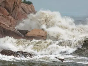
Typhoon Haiyan was among the strongest storms on record, and devastated a swathe of the Philippines. A storm surge was most damaging; and surges have hit Hong Kong.
In the aftermath of Super Typhoon Haiyan devastating a swathe of the Philippines on 8 November, several media articles have linked the storm’s ferocity to climate change. So too did Yeb Sano, lead negotiator for the Philippines at the United Nations Climate Talks held in Poland later in the month.
In an emotional speech three days after the storm hit, Sano said, “What my country is going through as a result of this extreme climate event is madness. The climate crisis is madness.”
Yet madness though the climate crisis may be, it is hard to definitively link Haiyan – known as Typhoon Yolanda in the Philippines – to climate change. Indeed, it is not even straightforward determining whether it truly was the strongest storm ever to make landfall.
The latter is largely based on the U.S. Navy’s Joint Typhoon Warning Center estimating that just before Haiyan made landfall its maximum sustained winds were 314 kph. The figure was derived from satellite observations, and is marginally higher than for the previous record holder, Hurricane Camille, which came ashore in the southeastern US in 1969, and close to the highest winds ever reliably measured in a tropical cyclone.
By another measure of strength – air pressure – Haiyan might rank as the 12th strongest tropical cyclone on record, according to Dr Jeff Masters of Weather Underground.
Typhoons and Climate Change
To some extent, debating Haiyan’s exact ranking among the strongest recorded storms is splitting hairs; it’s perhaps more important to note that it was close to the theoretical upper limit for tropical cyclones.
Masters wrote that Haiyan was powered by unusually warm sub-surface waters east of the Philippines – which were 4-5°C above average last month. One factor in causing this warmth may have been relatively strong trade winds in recent years. But also, the anomalous warmth is consistent with climate change.
A paper submitted to Geophysical Research Letters this spring analysed the warming west Pacific waters. In the main development region for typhoons, the tropical heat potential had become 10 percent higher than in the 1990s. This had made the region even more favourable for typhoon and super-typhoon intensification.
Professor Johnny Chan, Dean of School of Energy and Environment, City University of Hong Kong, has cautioned that warming Pacific Ocean temperatures need not necessarily result in more typhoons, as these also require stronger atmospheric circulations. Indeed, for 1960 to 2005 he found no increase in frequency of Pacific typhoons.
There is, however, some evidence that the strongest typhoons are becoming more intense, such as an analysis of 25 years of satellite data that was published in Nature in 2008. And a computer modelling study published this year forecasts that tropical cyclones will become both more intense and more frequent.
As Haiyan approached, a trio of storm chasers including Josh Morgerman headed to Tacloban – the city that would bear the brunt of the damage. While satellite imagery showed it was at least 400 kilometres in diameter, Morgerman reported that from the ground it seemed a small storm, with very destructive winds not starting until around 45 minutes before the centre’s closest approach. The main assault lasted only around two hours. “I’ve been in about twenty hurricanes, and this one was rather bizarre,” he commented.
Hong Kong’s Deadliest Typhoons
This sudden onset and swift passage was also a feature of one of Hong Kong’s deadliest typhoons. The unnamed storm struck on 18 September 1906, and the first warning was only given at 8am, with the typhoon gun fired 40 minutes later – by which time, the typhoon had already arrived. A report tells of the wind blowing at terrific force and a deluge of rain. By 11am, the typhoon had passed, and there was chance to survey the devastation.
Many ships and small boats were wrecked or smashed, and at least 10,000 people – perhaps 5 percent of the population – had been killed. Rather as with Haiyan, there was a destructive storm surge.
In 1937, another typhoon killed around 10,000 people, again with a devastating storm surge. In Victoria Harbour, the water rose almost 6 feet [2 metres] above normal height, reaching Des Voeux Road and Nathan Road. But it was Tolo Harbour that was most impacted. According to a record of the typhoon’s toll, “a tidal wave overwhelmed the fishing village of Tai Po, New Territories, and demolishing practically all the buildings and fishing boats, causing heavy loss of life. The wave was said to have been 18 feet [5.5 metres] high, and swept into Tide Cove and washed away almost a mile of the railway embankment….”
Here, perhaps, there is a similarity with the storm surge Typhoon Haiyan caused at Tacloban – where the water was also funnelled into a narrow bay, and piled onshore. Morgerman and colleagues had chosen a hotel supposedly 26 feet [8 metres] above sea level, yet even here the ground floor was flooded as water swamped much of the city.
Tolo Harbour is evidently prone to storm surges. Another occurred during the passage of Typhoon Wanda on 1 September 1962. An account by the Observatory suggested Wanda brought a dome of water up to 1.5 feet [0.5 metres] high and 100 miles [160 kilometres] across, and as it neared the coast this slowed down and its height increased. The intense winds then caused the water to build up in Tolo Harbour, with water covering the railway track in Sha Tin station.
Given this threat, when Sha Tin new town was built the reclamation was 3 metres higher than otherwise necessary. And every time a tropical cyclone approaches, the Observatory runs a storm surge model.
Recently, the city has been spared severe surges. But in September, we had a lucky escape. Typhoon Usagi followed a path similar to destructive typhoons of the past, but shifted just to the north of Hong Kong. The Observatory’s computer model suggested that with a more southerly track, there could have been a storm surge at least as strong as with Wanda.
As Haiyan approached the Philippines, there were warnings of a storm surge. Yet the mayor of Tacloban, Alfred Romuladez, later told CNN that “storm surge” meant little to people, and if warned of a tsunami they might have been better prepared. In Hong Kong, too, the notion of a storm surge might seem unthreatening. But eventually, another major surge will strike and – exacerbated by rising sea levels – will test Hong Kong with its modern infrastructure, perhaps causing damage in an object lesson about those forgetting the past being doomed to repeat it.
Written for Sunday Morning Post; published on 16 November 2013.
The Great Hong Kong Typhoon of 1937
Super Typhoon Haiyan preliminary report (pdf) by Josh Morgerman
Weather including tropical cyclones
Rare November Tropical Cyclones Including Typhoons in Hong Kong
As I write on 13 November 2024, Tropical Cyclone Toraji is set to pass over Hong…
Typhoons and Rainstorms Past Help Hong Kong Forecasts Today
Wetter, Wilder Weather Events Loom with Warming World You may find yourself on a Hong Kong…
“Typhoon to Hong Kong Soon” Makes Great Clickbait
While Hong Kong is sometimes hit by typhoons, predicting them in advance is tricky. Yet this…
Lightning-packed Supercell over Cheung Chau, Hong Kong
Yesterday evening (30 April 2024), weather monitoring imagery showed an intense rainstorm/thunderstorm area – a “supercell”…


HK Observatory warns re typhoons n climate change
From 21 November S China Morning Post:
[quote]Observatory warns of increased floods and more powerful typhoons
Climate change will also bring an increased risk of flooding as sea levels rise, Observatory says
The city should brace itself for increasingly powerful typhoons and more widespread flooding in the next few decades as the climate warms and sea levels rise, the Hong Kong Observatory has warned.
Sea levels are expected to rise by 40cm on average by the middle of the century as temperatures increase by at least two degrees Celsius, Observatory meteorologists said.
"Hong Kong is like a frog in water that is gradually being brought to the boil; people do not seem to be aware of the long-term effects of climate change," said Observatory assistant director Edwin Lai Sau-tak.
Low-lying flood black spots such as San Tin and Shek Wu Wai in Yuen Long, and areas in Tai Po and North district, would be at higher risk of extreme flooding.
By the end of the century, sea levels are forecast to rise by 80cm and temperatures by between three and six degrees, according to new Observatory data.
Referring to the 2004 Hollywood movie The Day After Tomorrow, which portrayed a world suffering disasters brought on by global warming, Lai said: "I think The Day after Tomorrow actually happened yesterday."
The Observatory sounded the warning based on an analysis of the latest report issued by the Geneva-based Intergovernmental Panel on Climate Change, (IPCC) a scientific body operating under the auspices of the UN.
Government bodies should take into account the new data and review their risk assessments for infrastructure, buildings and drainage and flood control, the Observatory said.
In April, weather officers will cast out to sea new floating sensors to obtain more accurate measurements of storm strength.
The intensity of storms is expected to become much greater, Observatory officials said, although their frequency is not expected to increase significantly.
Average daily temperatures in the city have risen 1.2 degrees since 1913, Observatory records show. Mean sea levels in Victoria Harbour have gone up by 29 millimetres per decade since 1954.
The intergovernmental panel released its most comprehensive study on climate change last month. It said there was a 95 per cent chance carbon-intensive human activity had caused the rise in global temperatures in recent decades.[/quote]
http://www.scmp.com/news/hong-kong/article/1362359/observatory-warns-increased-floods-and-more-powerful-typhoons
New York threatened by climate change
Long piece in Rolling Stone, should be thought provoking for Hong Kong too:
http://www.rollingstone.com/politics/news/can-new-york-be-saved-in-the-era-of-global-warming-20160705?page=11
Storms threaten Hong Kong
From a China Daily article: