2 October 2008 at 1:55 am
#8215
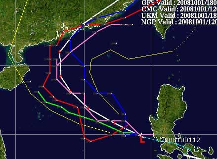
Higos has now moved clear of the Philippines, and currently ranked only as tropical depression, but forecast to intensify – to typhoon status (albeit not powerful tyhoon); also forecast to head roughly northwest, then curve north and northeast before landfall.
Current forecast tracks – seen via http://cimss.ssec.wisc.edu/ – route Higos very close to Hong Kong, with direct hit possible. Pretty good agreement between forecasts.
But – bummer for lovers of weekends and fans of Number Eight leading to day off work – HK Observatory reckons it will be closest on Sat and Sun, maybe nearest during Saturday (4 October) night.