
- This topic has 24 replies, 2 voices, and was last updated 14 years ago by
 DocMartin Williams.
- AuthorPosts
- 17 October 2010 at 3:16 pm #7221
Updates and images on Super Typhoon Megi, which has crossed Luzon from east to west, killing at least 11 people, and is now headed towards South China, with forecast tracks suggesting it could come close to Hong Kong – landfall maybe east Guangdong.
Before landfall over Luzon, it packed extremely powerful winds, reaching 230 km/hr over 10-minute average: making it one of three strongest tropical cyclones ever recorded.
In Philippines, known as Typhoon Juan. Passage over Luzon weaken the storm somewhat, but it re-entered the South China Sea with typhoon strength. Movement uncertain, but it may slow down, re-intensify, and turn poleward – possibly coming fairly close to Hong Kong.
Here's video from the Philippines, by James Reynolds aka typhoonhunter: taken during storm as eye passed close by, and in aftermath of eye passing over:
[video:http://www.youtube.com/watch?v=R9tckfJrTnI%5D
Currently, it seems Hong Kong will at least be affected by strong winds and rain from Megi.
[post edited on 21 October]
18 October 2010 at 4:40 am #8531Super Typhoon Megi now battering Luzon; arrived with air pressure of 885mb, making it one of the strongest typhoons/hurricanes recorded making landfall (Wikipedia: Typhoon Megi).
Forecast to weaken a bit, hit S China Sea, then turn, and possibly close to HK (tho not so mighty).
18 October 2010 at 8:48 pm #8534 Anonymous
So will it hit Hongkong?
19 October 2010 at 12:53 am #8535Still can't say for sure if a direct hit is likely, but it's possible.
ECMWF computer models now seem an outlier in forecasting westerly track, with landfall close to Hainan (even though preferred by Joint Typhoon Warning Center as ECMWF has performed best w Megi so far). Some forecasts are for landfall east of HK.
HK Observatory forecast tracks since late yesterday have been pointing pretty much at HK. With Typhoon Lionrock in early days, I'd thought they were out of synch with developments, yet the Observatory forecast proved good I thought.
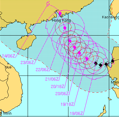
Here's actual and forecast track from Joint Typhoon Warning Center, which is based on assessment of several model forecasts. At landfall, winds 90 knots, or 166km/hr – well above the 118 km/hr needed to classify a tropical storm as a typhoon; winds rather stronger, at 100 knots, shortly before landfall.
 19 October 2010 at 7:39 am #8536
Latest from ECMWF; no longer has Megi making landfall towards Hainan. Instead, hitting Hong Kong. Agrees with some other forecasts.
There's plenty of potential for the storm to veer to east or west of Hong Kong, but seems HK will feel at least strong impact of Severe Typhoon Megi (as it's known by HK Observatory).

See also latest from Joint Typhoon Warning Center: Can't have more direct hit than this! – though of course, tropical storms are quirky beasts, and even with increasingly sophisticated forecasting models they can move in unexpected ways.
 19 October 2010 at 11:31 am #8537
I've noticed colourful, purple tinted clouds at dusk before a typhoon or two. This evening, there was also intense colour at dusk; shot here of Cheung Chau harbour.
 19 October 2010 at 12:10 pm #8538Anonymous
so, what is the impact to hong kong going to be and when? i’m scheduled to fly out on friday morning from hong kong…
19 October 2010 at 12:49 pm #8539No one knows for sure what the impact will be.
But even with worst-case, direct hit scenario, looks like conditions won't be too bad on Friday morning, so I'd expect flights to still be normal or pretty much so. More impact later Friday, and especially Saturday 23 October.
20 October 2010 at 2:28 am #8540Seems there's shift in forecast tracks, with landfall looking more likely to east of Hong Kong. Though China's National Meteorological Center forecasts the storm coming very close to Hong Kong, and making landfall around Macau.
Here's latest from Joint Typhoon Warning Center; latest from HK Observatory is very similar to this.
20 October 2010 at 7:30 am #8541Megi is still heading north; outer rainbands clearly visible on Hong Kong Observatory radar (within 280km). Yet, no storm signal issued in Hong Kong. Some complaints about this on Weather Underground forum; even suggestions it may be as issuing signals can upset big businessmen.
HK Obs' own info on T1:
"This is a stand-by signal, indicating that a tropical cyclone is centred within about 800 km of Hong Kong and may affect the territory."
Absurd not to follow this – in the past have been several occasions when "standby" signal issued and not a lot then happened, and that's fair enough. Didn't feel the Observatory lost face by issuing signal, nor did business suddenly shut down or anything.
Now, major typhoon, forecast to at least be close enough to bring some strong winds and rain – which means it surely will affect HK.
Issuing T1 by time a storm actually is affecting Hong Kong goes against intent of "standby" signal.
The wind is freshening here on Cheung Chau (doesn't look as if that's the case checking real time wind records, yet trees blowing about more with wind whistling through them, sea is somewhat rougher): combination of ne monsoon and typhoon?
As far as procrastination goes, I'd wonder if storm surge scenario really seemed possible or starting: would people in areas like Tolo Harbour get info in time?Also:
S China Morning Post today had story on places in S China, including Hainan, preparing for the typhoon. Some evacuations underway.
I know we stay put in Hong Kong, yet seemed odd there wasn't mention of any preparation locally.
Latest 256-km radius radar image here:
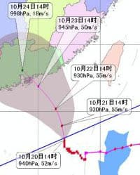
And here, 2pm forecast track from China's National Meteorological Center:
 20 October 2010 at 8:54 am #8542
As Megi approaches, Number 1 stand by signal issued at 4.35pm today.
20 October 2010 at 11:57 am #8543AnonymousHi, i was just wondering if now you can tell if typhoon Megi will hit Hong Kong. If yes, will it be a typhoon 8 and when?
Thanks
Georges20 October 2010 at 12:51 pm #8544Hi Georges:
Still can't say for sure: only hindsight really works with most weather forecasts, including typhoons!
Looking at some forecast tracks, as well as Weather Underground discussion, seems "smart money" is on landfall to east of Hong Kong, so the eye – with the most intense winds – looks likely to miss us. But still, small deviation from forecasts could lead to hit.
Seems likely to be closest late Friday and during Saturday.
Bit of surf along coast of Cheung Chau this evening, as winds began picking up. Waves partly from offshore swell radiating from Megi.
 20 October 2010 at 12:53 pm #8545Anonymous
When will megi hit hk?
20 October 2010 at 2:28 pm #8546IF Megi hits, looks likeliest to be during Saturday 23 October, perhaps late in the day.
HK Observatory track (issued 10pm – half an hour ago) has it moving north, and later curling northwest, to come near HK. National Meteorological Center (8pm) is much the same, and NMC has been consistent in forecast.
ECMWF forecast model not so fabulous with this storm; not so many posts ago, had the storm bound towards Hainan; has moved landfall eastwards, inc direct hit on HK, and now forecasting east of HK. UK Met Office forecast recently had the storm moving north, then suddenly turning west to pass HK: a sign that some change in steering is possible that might swing Megi towards us.
So let's see.
Worth remembering this hit Luzon as one of strongest tropical cyclones on record. Even somewhat weaker, Megi remains mighty.
Hong Kong Observatory may issue Number 3 soon – which is contrary to earlier announcement that they did not anticipate Number 3 tonight. Suggests Megi is moving more towards HK than they had forecast.
- AuthorPosts


- You must be logged in to reply to this topic.