
- This topic has 9 replies, 1 voice, and was last updated 11 years, 9 months ago by
![]() DocMartin Williams.
DocMartin Williams.
- AuthorPosts
- 21 September 2013 at 1:39 am #7379
After some remarkably consistent forecasts for a powerful typhoon hitting Hong Kong or very close by – including from ECMWF computer model – Super Typoon Usagi is now nearing Luzon strait, south of Taiwan, and indeed looks set to come very close indeed.
If it passes over land, a little to north of us, surely won't be severe impact. [This is what happened; HK had a lucky escape!]
Otherwise, even if eye passes somewhat to south, highly threatening.
Here's post from Washington Post weather blog:
Quote:Super typhoon Usagi, 2013′s strongest storm on the planet, may have peaked in intensity, but remains an extremely dangerous cyclone as it continues on a collision course with southern Taiwan and, likely, Hong Kong.The Joint Typhoon Warning Center says Osagi’s maximum sustained winds are 150 mph, the equivalent of a category 4 hurricane. That’s down from at least 160 mph Thursday (category 5 level). But this is a mammoth storm, tropical storm force winds span 275 miles across it.
On Thursday evening, a satellite-based estimate of its minimum pressure was an astonishingly low 882 mb, which would have made it the deepest and most intense storm to exist on Earth since 1984 (tied with Wilma in 2005).
Monstrous super typhoon Usagi holding its own, Hong Kong braces for possible impact
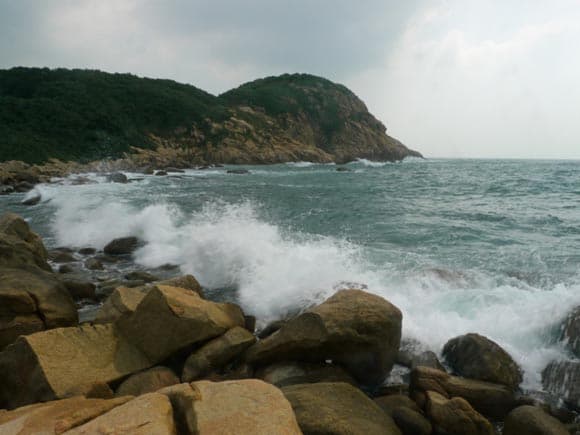
While here's a shot from Shek O yesterday. Waves not so great – but this was fair surf given there was barely a breath of wind, and Usagi was over 800km away [not sure of distance: a long way to be sending waves like this though]
![shek o usagi surf]() 21 September 2013 at 1:48 am #8859
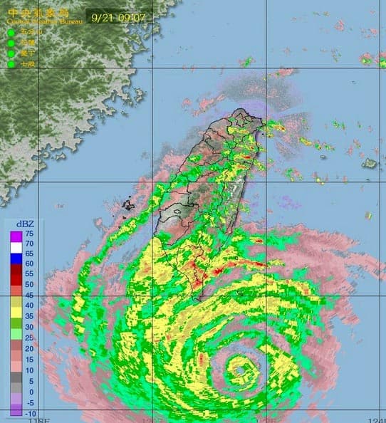
21 September 2013 at 1:48 am #8859Double eyewall seen in Taiwan radar image: new circle of intense rainband formed around centre, where moisture will soon drop, and new eye likely to form [eyewall replacement]. A feature of powerful tropical cyclones.
![usagi double eyewall]() 21 September 2013 at 2:11 am #8860
21 September 2013 at 2:11 am #8860If Usagi passes over or just south of Hong Kong, storm surge could be a massive threat – somewhat caused by dome of water "sucked up" by low pressure, but chiefly with water piled inshore by the powerful winds.
Long time since a mighty storm surge in Hong Kong, but historically not rare.
From account of Typhoon Wanda, in 1962:
Quote:In Sha Tin Village Police Post the high water mark was 17'3" above chart datum or 5' above road level. At the railway station high water was over the railway track but below the level of the platform. The water was reported to rise very quickly for 10 or 15 minutes, and the highest level lasted for 10 – 15 minutes some time between 10.30 and 11.30 a.m. At the aerodrome there were two high water marks both about 6 ft. above the level of the airstrip, which is 10 ft. above chart datum.…
Destructive tidal surges were reported in Tolo Harbour in 1874, 1906, 1923 and 1937 but only the latter is considered here. The Typhoon of 1937 occurred only one day later in the year on September 2. The centre passed about 7 miles south of the Royal Observatory at 4.30 a.m. compared with "WANDA" which passed 10 miles south of the Royal Observatory at 10.45 a.m. Tides in the harbour in 1937 were estimated to be 6 ft. above normal and the tidal wave in Tolo Harbour was reported to be about 30 ft. high. However there were no tide gauges in Tolo Harbour and the stationmaster at Sha Tin said that there was practically no difference between the two typhoons in the maximum heights reached at the Railway Station. It has been(i) estimated that the high water mark in Tai Po left by the 1937 typhoon was about 20 ft. 6 inches above chart datum.
The main difference between the two typhoons is that the 1937 typhoon occurred in darkness and the flooding was totally unexpected. Fatalities were estimated at 11,000 compared with 127 in "WANDA".
August 27 to September 2, 1962
21 September 2013 at 3:50 am #8861Quote:China's national observatory on Saturday issued the highest level of alert for super typhoon Usagi which was expected to bring gales and rainfall to the coastal areas and land in Guangdong Province between Sept. 22-23.The National Meteorological Center (NMC) upgraded the warning to the red alert, the highest level, from the previous yellow-coded one issued on Friday afternoon.
http://news.xinhuanet.com/english/china/2013-09/21/c_132737269.htm
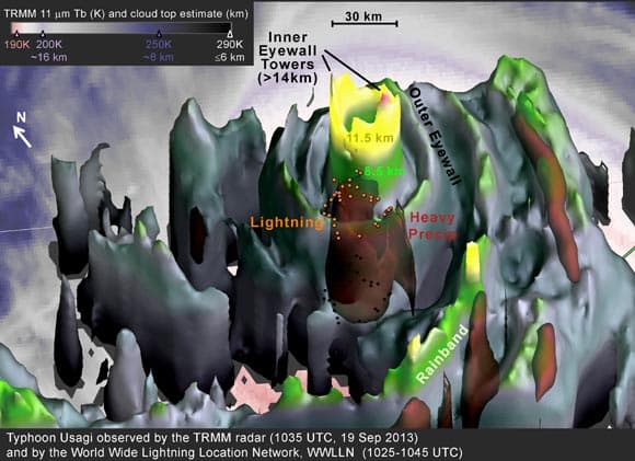
21 September 2013 at 6:17 am #8862News from NASA:
![usagi seen by nasa]()
Includes:
Quote:The radar on the Tropical Rainfall Measuring Mission (TRMM) satellite captured an image of Supertyphoon Usagi near the end of a 24-hour period in which Usagi intensified by 65 knots. This is more than twice the commonly used 30-knot threshold for defining rapid intensification.The TRMM data was used to create a 3-D image. The data was collected at 1035 UTC/6:35 a.m. EDT on Thursday, September 19, 2013, when Usagi was at category 3 on the Saffir-Simpson hurricane intensity scale. A few hours later, Usagi completed its lightning-fast intensification to category 5, the highest category in the scale.
but few tropical cyclones have such symmetric eyewalls as does Supertyphoon Usagi in the TRMM 3-D image.
NASA Sees Super-rapid Intensification of Supertyphoon Usagi
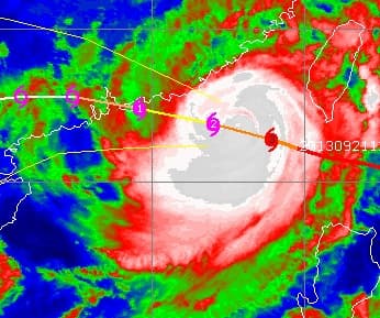
22 September 2013 at 1:14 am #8864Typhoon Usagi is bearing down on Hong Kong . Winds fresher, but not strong yet; but rain just arriving, and this image plus HK Observatory radar show rainbands due soon – can expect more wind in these. Some of energy from Category 5 period has spread into the storm; so could be some potent winds in the rainbands too.
Maybe to hit land just east of Hong Kong, so might be little storm surge. Maybe….
![usagi nearing hk]() 22 September 2013 at 7:54 am #8865
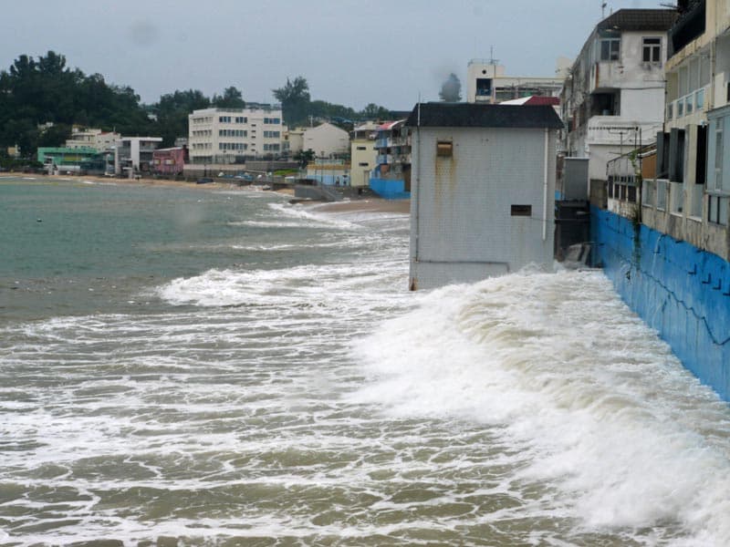
22 September 2013 at 7:54 am #8865During high tide at Cheung Chau today, minor storm surge (around 0.5m), with fair waves even tho sea looking about flat calm, and with little wind.
![usagi minor storm surge]() 22 September 2013 at 8:11 am #8866
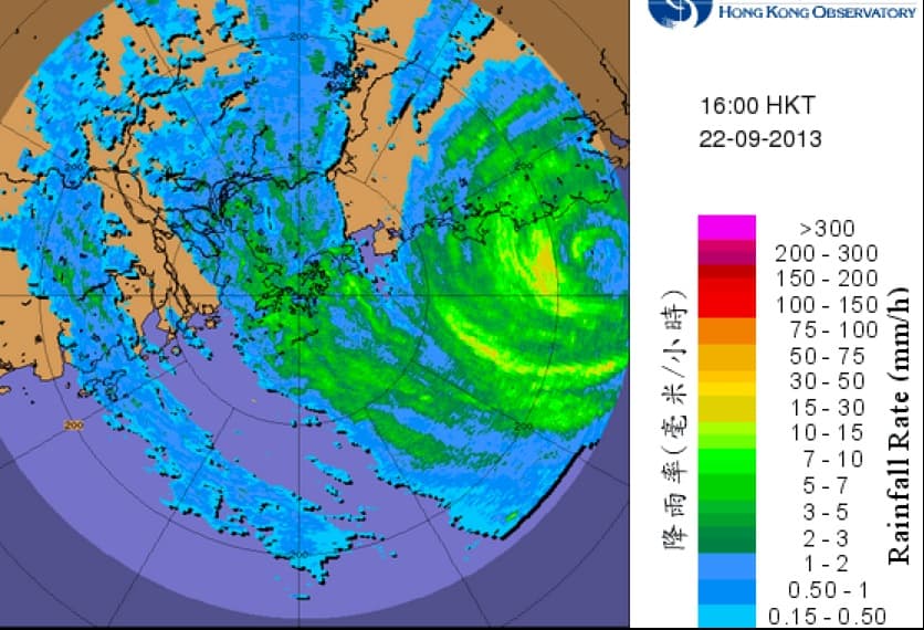
22 September 2013 at 8:11 am #8866HK Obs radar now showing centre of Usagi; eye somewhat ragid as it nears Shanwei, to east of Hong Kong.
Looks set to continue roughly west-northwest, pass overland to north of Hong Kong.
![usagi near shanwei]() 23 September 2013 at 1:41 am #8867
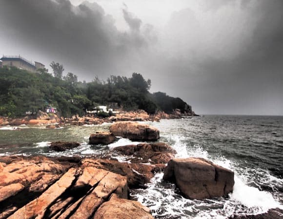
23 September 2013 at 1:41 am #8867Typhoon signal down to T3. And in continuing efforts to bring you all the drama, almost as it happens [haha], a shot from south Cheung Chau earlier this morning.
Even with best dramatic tone effect, well…
HK was lucky, with storm hitting land to east [near Shanwei], heading past to north of us: less wind, only small storm surge.
![usagi afterwards]() 28 September 2013 at 1:13 pm #8868
28 September 2013 at 1:13 pm #8868Post on HK Observatory director's blog concludes:
Quote:What would happen then if Usagi took on a track of about 100 kilometres[4] southward when it was near Hong Kong (red line in Figure 5) with the time of occurrence of storm surge matching with that of the astronomical high tide? Computer storm surge simulated results (Figure 6) showed that storm surge of about 1.7 metres would occur at Quarry Bay[5] and added up with the astronomical high tide (2.2 metres), resulting in a sea level of nearly 4 metres, rather close to that caused by Wanda in 1962. If Usagi took on an even more southward track (green line in Figure 5), the simulated storm surge would be even larger. Severe storm surge was so close – we just escaped from repeating history! - AuthorPosts
- You must be logged in to reply to this topic.