
While Sok Kwu Wan is familiar as a coastal village dominated by seafood restaurants, it’s also a good starting place for an easy hike to explore the relatively little visited, wild south of Lamma – which is like a corner of the far-flung New Territories.
If you start the hike at the Sok Kwu Wan ferry pier, turn right, along the narrow street lined with restaurants. In the early morning, most are quiet, with perhaps only a handful of people at a couple of places serving breakfast – reflecting the fact few people in this area, and though there are boats on the water close by, there is no longer a thriving fishing community here.
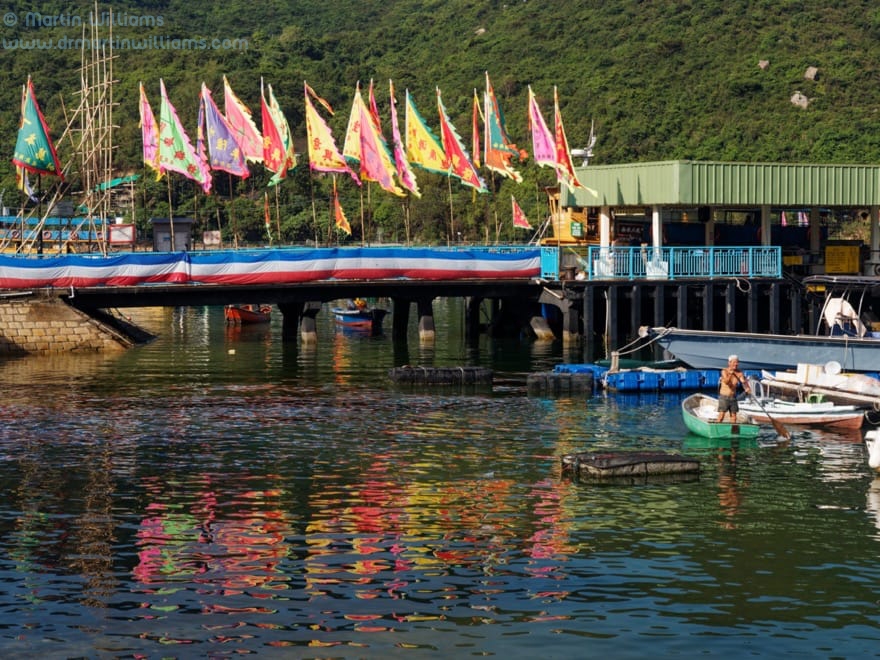
There’s still a well-maintained temple to Tin Hau, goddess of local fishermen, which you arrive at just after the restaurants. Just in front of it, a signpost indicates a concrete path uphill, along the South Lamma Family Walk towards Tung O.
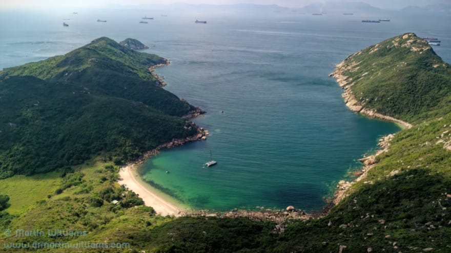
The path leads into woodland with slender trees and bamboo. The inlet sheltering Sok Kwun Wan is soon lost from view, and in summer there may be few sounds other than the incessant buzzing of cicadas. Even at a gentle pace, it takes less than half an hour before you emerge to hillsides with grass, scrub and boulders, and a side trail to the right leads to a pavilion affording splendid views of southern Lamma.
A map indicates the pavilion is 136 metres above sea level, 217 metres lower than Lamma’s highest peak, Mount Stenhouse – which dominates the landscape to the west. Another hill rises to the northeast, with its southern slopes dropping down to Tung O Wan, beyond which lie southern Hong Kong Island and Po Toi. Looking south, the land drops to a sheltered inlet, Sham Wan.
Dreams of Sea Turtles
You can visit Sham Wan by walking down the family trail from near the pavilion, and turning right just before the hamlet of Tung O. Again there’s a concrete path, passing a fine banyan tree, then following the edge of an almost level valley floor that may have been cultivated but is now overgrown with rank grassland.
After perhaps five minutes’ walk, the concrete gives way to dirt path, and there are rough steps to trees and scrub fringing a sandy beach. Now, you might think it wonderful to arrive at a beach in the height of summer – but note that this one is closed to visitors from 1 June to 31 October, and you could be fined HK$50,000 for setting foot on the sand here.
This restriction aims to safeguard nesting Green Turtles, as by late last century Sham Wan was the only regular nesting site for this species in Hong Kong. Sadly, the last nesting was in 2012, but conservationists hope turtles born then or in previous years will return once mature and ensure these magnificent animals – which can grow to over 1.5 metres long and weigh over 200 kilograms – continue breeding here.
During summer, you might skirt around the top of the beach, and view the bay from the rocky shores to east and west. There might be pleasure boats in the bay, as there are no restrictions on access to the water, meaning turtles are disturbed or deterred before even reaching the beach.

A beach you can walk on
The family trail continues eastward from Tung O. Just after the hamlet, there is a wonderful, east facing bay, Shek Pai Wan. This has a beach over 400 metres long, with fine sand you can walk on year round, and shallow waters suitable for swimming – taking care, as there is no lifeguard service.
A cluster of boulders forms an islet close inshore, as if a giant had playfully dropped them in place to enliven the scenery. Rocky reefs also flank the mouth of the bay. Beyond, there is just sea and islands – for the time being, as a developer has ideas for building housing with a marina in southeast Lamma, though happily plans have so far been rejected over environmental concerns.
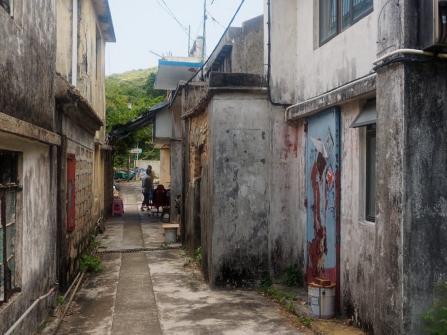
There’s another hamlet, Yung Shue Ha, at the east of the bay. Like Tung O, it seems mostly deserted by all but a handful of residents, who make a little income by selling drinks and simple food to passing hikers.
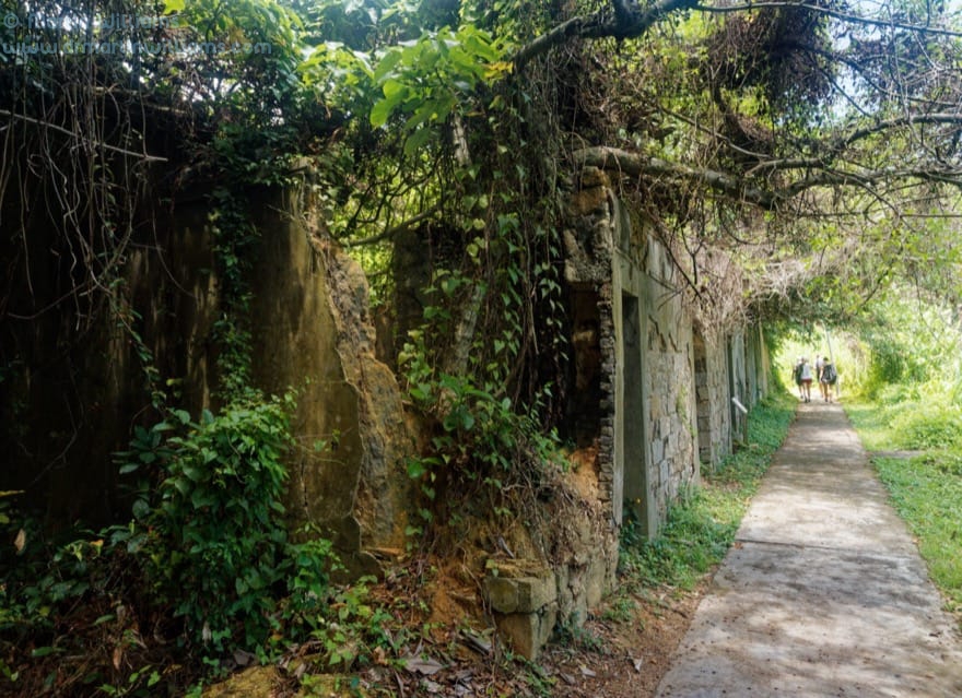
From here, the path turns inland a little, and soon arrives at a row of ruined houses with trees sprouting in former living rooms. A sign notes that this was the site of the original Yung Shue Ha – established around 200 years ago, but later abandoned as the village was relocated to beside the shoreline.
The path leads through woodland, and climbs a little, passing another ageing hamlet, Mo Tat Old Village. Soon after this, there are a handful of Spanish style villas by the path, in Mo Tat New Village. There’s an information board on Mo Tat, where someone has crossed out most of the last sentence, saying “These days, however, most young villagers have left for greener pastures in the city,” and scribbled a revision to say, “These days, more than 100 people of all ages live in Mo Tat.”
From here, the path descends to a north facing shore, and the family trail turns west, with a rather dull section taking you back to Sok Kwu Wan.
Getting there
Sok Kwu Wan is served by ferries from Central, and from Aberdeen. The Aberdeen ferry also stops at Mo Tat, so could be worth considering for the return journey if you want to omit the rather dreary stretch from near here to Sok Kwu Wan.
[Written for the South China Morning Post.]


