
- This topic has 2 replies, 1 voice, and was last updated 11 years, 10 months ago by
 DocMartin Williams.
- AuthorPosts
- 27 June 2012 at 3:12 am #7312
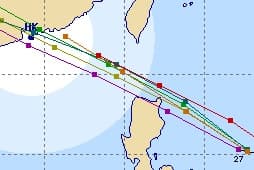
Tropical Storm Doksuri has formed to the east of the Philippines. There's good agreement from forecast tracks that it will come close to Hong Kong in around three days – so closest 30 June/1 July. However, not forecast to intensify much – so likely to be "only" a tropical storm as it passes. Still, early days yet…

Here's a combination of forecast tracks, from http://www.typhoon2000.ph/imatcf/?name=DOKSURI
27 June 2012 at 11:04 am #8763Forecast tracks still in close agreement; Joint Typhoon Warning Centre forecasting almost severe tropical storm strength before landfall, and passing over HK Island.
Which could mean it will fade to nothing and turn to somewhere well outside HK! [as storm forecasts rarely prove very accurate]
28 June 2012 at 2:43 pm #8764From HK Observatory:
Quote:The Standby Signal, No. 1 is in force.This means that a tropical cyclone now centred within about 800 kilometres of Hong Kong may affect us.
At 10 p.m., Tropical Storm Doksuri was estimated to be about 750 kilometres east-southeast of Hong Kong (near 20.0 degrees north 121.0 degrees east) and is forecast to move west-northwest at about 25 kilometres per hour entering the South China Sea.
According to the present forecast track, Doksuri is expected to move closer to the south China coastal areas tomorrow (29 June, Friday). Local weather will deteriorate later tomorrow and on Saturday with squally showers and winds strengthening.
As Doksuri is still at a distance from Hong Kong, the chance of issuing the strong wind signal, No.3 tomorrow morning is not high.
- AuthorPosts
- You must be logged in to reply to this topic.