
- 主題有 24 個回复,2 個參與人,最後更新 13 歲零 9 個月前 經過
 醫生馬丁·威廉姆斯.
- 作者文章
- 17 2010 年 10 月 3:16 下午 #7221
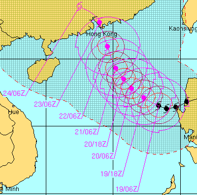
超強颱風「梅姬」的最新情況和圖像,該颱風已從東向西穿過呂宋島,造成至少11 人死亡,目前正向華南地區移動,預測路徑顯示,它可能會靠近香港——可能會在廣東東部登陸。
在登陸呂宋島之前,它帶來了極其強大的風力,平均風速在 10 分鐘內達到 230 公里/小時:使其成為有史以來最強的三個熱帶氣旋之一。
在菲律賓,被稱為颱風胡安。經過呂宋島後,風暴強度減弱,但以颱風強度重新進入南海。運動不確定,但可能會減慢、重新加強並轉向極地 — — 可能會相當接近香港。
這是來自菲律賓的視頻,由詹姆斯·雷諾茲(又名颱風獵人)拍攝:在暴風雨期間,風眼經過時以及風眼經過後拍攝:
[視頻:http://www.youtube.com/watch?v=R9tckfJrTnI%5D
目前看來,香港至少會受到鮎魚強烈風雨的影響。
[10月21日編輯的貼文]
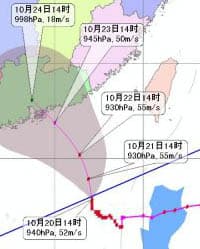
2010年10月18日 4:40 上午 #8531超強颱風「美姬」正在攻擊呂宋島;抵達時氣壓為 885mb,是有紀錄以來登陸最強的颱風/颶風之一(維基百科: 颱風梅姬).
預計會稍微減弱,觸及南中國海,然後轉向,並可能接近香港(雖然不是那麼強大)。
18 2010年10月18日 下午 8:48 #8534 匏名
匏名那麼它會襲擊香港嗎?
2010年10月19日 上午 12:53 #8535仍然不能確定是否有可能發生直接打擊,但這是可能的。
ECMWF 電腦模式現在在預測西風路徑方面似乎是一個異常值,登陸地點靠近海南(儘管聯合颱風預警中心更傾向於使用 ECMWF,因為迄今為止 ECMWF 在 Megi 上的表現最好)。一些預測是在香港東部登陸。
自昨天稍晚以來,香港天文台的預測軌跡幾乎都指向香港。颱風獅山初期,我以為與事態發展不同步,但天文台的預報證明我認為是好的。
這是聯合颱風預警中心的實際和預測軌跡,基於對多個模型預測的評估。登陸時,風速為 90 節,即 166 公里/小時,遠高於將熱帶風暴歸類為颱風所需的 118 公里/小時;登陸前不久,風力相當強勁,風速為 100 節。
 2010年10月19日 7:39 上午 #8536
ECMWF 最新消息;鯽魚不再登陸海南。而是去香港。同意其他一些預測。
風暴很有可能轉向香港東部或西部,但香港似乎至少會感受到強烈颱風鮎魚(香港天文台所稱)的強烈影響。

另請參閱聯合颱風預警中心的最新消息:沒有比這更直接的打擊了! – 當然,熱帶風暴是一種古怪的野獸,即使有了日益複雜的預測模型,它們也可能以意想不到的方式移動。
 2010年10月19日 上午11:31 #8537
我注意到在一兩場颱風到來之前的黃昏時會出現色彩繽紛的紫色雲彩。今晚,黃昏時分色彩也很濃烈;長洲港在此拍攝。
 2010年10月19日 12:10 下午 #8538匏名
那麼,對香港將會產生什麼影響以及何時產生影響?我預定週五早上從香港起飛...
2010年10月19日 12:49 下午 #8539沒有人確切知道會產生什麼影響。
但即使出現最壞的情況,即直接受到打擊的情況,週五早上的情況似乎也不會太糟糕,因此我預計航班仍將正常或基本正常。週五晚些時候,尤其是 10 月 23 日週六,影響更大。
2010年10月20日 2:28 上午 #8540預測路徑似乎發生了變化,登陸看起來更有可能在香港東部。儘管中國國家氣象中心預測風暴將非常接近香港,並在澳門附近登陸。
這是聯合颱風預警中心的最新消息;#39;香港天文台的最新消息與此非常相似。
2010年10月20日 7:30 上午 #8541梅吉仍在向北行駛;外圍雨帶在香港天文台雷達上清晰可見(280公里以內)。然而,香港並沒有發出暴風雨信號。對此的一些投訴 地下天氣論壇;即使是建議,因為發出信號也會讓大商人感到不安。
香港觀察'; T1 自己的信息:
“這是一個待命信號,顯示有熱帶氣旋集中在距離香港約800公里範圍內,可能影響本港。”
不遵循這一點是荒謬的——過去曾多次發出“待機”信號,但隨後發生的情況並不多,這很公平。沒有覺得天文台發出信號丟面子,也沒有突然停業什麼的。
現在,預計強颱風至少會帶來強風和降雨,這意味著它肯定會影響香港。
在風暴實際影響香港時發出T1,違背了“待命”信號的本意。
長洲這里風清了(看實時風力記錄好像不是這樣,但樹木吹得更多,風呼嘯而過,海面有些洶湧):季風和颱風的結合?
就拖延而言,我想知道風暴潮情景是否真的可能或正在開始:像吐露港這樣的地區的人們會及時獲得信息嗎?另外:
華南早報 今天有關於海南等中國南部地區為颱風做準備的報導。一些疏散工作正在進行中。
我知道我們留在香港,但似乎很奇怪'沒有提到任何當地的準備工作。
最新的 256 公里半徑雷達圖像在這裡:
這裡是中國國家氣象中心下午 2 點的預報軌跡:
 2010年10月20日 8:54 上午 #8542
隨著 Megi 的臨近,今天下午 4.35 發出了 1 號待命信號。
2010年10月20日 11:57 上午 #8543匏名你好,我想知道現在你是否知道颱風鮎魚是否會襲擊香港。如果是的話,會是8號颱風嗎?什麼時候?
謝謝
喬治斯2010年10月20日 12:51 下午 #8544嗨喬治:
仍然不能肯定地說:只有事後諸葛亮才真正適用於大多數天氣預報,包括颱風!
看看一些預報軌跡以及地下天氣的討論,似乎「聰明的錢」正在香港東部登陸,所以風眼——伴隨著最猛烈的風——看起來很可能會錯過我們。但儘管如此,與預測的微小偏差也可能導致打擊。
似乎最接近的時間可能是周五晚些時候和周六。
今晚長洲沿岸有小浪,風力開始增強。波浪部分來自近海,從梅吉輻射出來。
 2010年10月20日 12:53 下午 #8545匏名
megi什麼時候登陸hk?
2010年10月20日 下午2:28 #8546如果 Megi 似乎最有可能出現在 10 月 23 日星期六,也許當天晚些時候。
香港天文台軌跡(晚上10點至半小時前發布)顯示它向北移動,隨後向西北捲曲,接近香港。國家氣像中心(晚上8點)大致相同,NMC的預報也一致。
ECMWF 預測模式對這場風暴來說並不是那麼美妙;沒那麼多貼文之前,風暴就已經駛向海南;已向東登陸,直接襲擊香港,現預測將在香港東部登陸。英國氣象局最近預測風暴將向北移動,然後突然向西轉向經過香港:這表明轉向可能會發生一些變化,可能會將梅吉轉向我們。
讓我們看看。
值得記住的是,這次襲擊呂宋島是有史以來最強的熱帶氣旋之一。即使稍微弱一些,梅吉仍然很強大。
香港天文台可能很快就會發布第3號——這與之前宣布的他們預計今晚不會發布第3號的消息相反。顯示 Megi 向香港的發展程度超出了他們的預期。
- 作者文章


- 抱緊,回歸主題必須先登錄。