
 Hong Kong's highest mountain, Tai Mo Shan, dominates the central New Territories.
Hong Kong’s highest mountain, Tai Mo Shan, dominates the central New Territories.
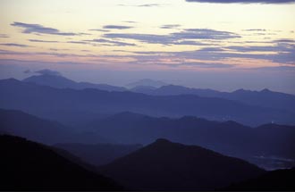
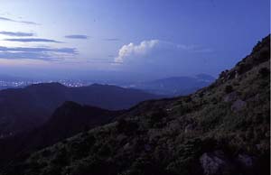
Hong Kong’s highest mountain, Tai Mo Shan (大帽山), dominates the central New Territories north of Kowloon. Its name means “Big Hat Mountain” or “Big Misty Mountain”, after the low cloud and mist that often swirls around the summit. Though just 957 metres high, it deserves to be called a mountain, not a hill – as it’s such an imposing presence in the landscape.
Though seasoned hikers once liked to accompany newbies to the summit, then enjoy the sight of them tumbling into a concealed hollow, Tai Mo Shan is no longer a major peak to climb, as there’s a service road to a communications facility and other paraphernalia perched on top. But this service road is closed to most vehicles, and makes for pleasant strolling on the upper reaches of Tai Mo Shan – especially on a clear day when Hong Kong’s summer heat is on, and the temperature here can be just a tad cooler.
(On rare winter days, the temperature here can dip below freezing – when cold weather is forecast, some Hongkongers drive up before dawn, in the hope of seeing frost.)
Tai Mo Shan reigns over Hong Kong’s New Territories
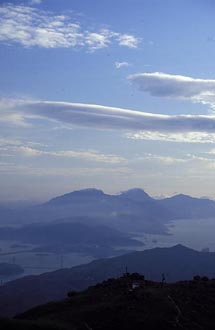 The service road starts at a car park, high on Tai Mo Shan. There’s a barrier you can walk past, and the road angles fairly gently up the hillside, which is grassy, dotted with big boulders. On a clear day, you can look north, across the Shek Kong Plain way below, to Deep Bay, and Shekou in mainland China beyond; there are rolling hills to the west, then Lantau Island, and Kowloon and the western harbour.
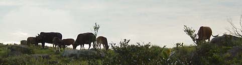 The hillsides are peaceful. Maybe you’ll encounter a few strollers; perhaps also a herd of feral cows, descendants of farm animals that now live wild in these hills. (Happily, these cattle seem pretty docile; I’ve walked close by a bull or two, without them seeming at all bothered – while I was wondering how fast I could run if they even thought about approaching me.)
The road winds more steeply uphill, passing a small valley with dwarf bamboo. There’s a broken old fence that once marked off a small grassy hilltop on the right, and just after this, a rough track heads right. Though you can continue up the road to almost the top of Tai Mo Shan – and then down, to perhaps hike past the Ng Tung Chai waterfalls, or on to Leadmine Pass above Shing Mun Reservoir – this track makes for a pleasant diversion, and perhaps for enough of an outing on a hot afternoon.
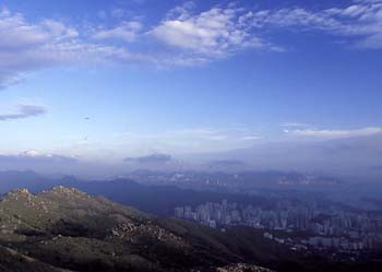 The track dips slightly, and the view to the south opens out – there are rough, grassy slopes below, the Kowloon Hills including Lion Rock beyond, and Victoria Harbour and Hong Kong Island in the distance. (If you’re lucky, that is! All too often smog wafts in from mainiand China, obscuring such views; but the scene can be clear as crystal when there’s a breeze from the south.)
There’s little else here; a concrete path drops to a small ravine, to a tiny dam hidden amidst trees. You should hear birds – and if you’re a birder, perhaps you’ll find some of the species that in Hong Kong are mostly found high on Tai Mo Shan.
Then, perhaps that’s enough exploring Tai Mo Shan for today. If you started around mid-afternoon, perhaps you’ll emjoy a spendid sunset as you walk back down.
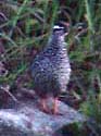
And if it’s around sunset on a spring or summer’s day, chances are that Chinese francolins will be “singing”: Come to the Peak, ha ha!
From Tsuen Wan, take bus 51 from road over MTR station, then walk up from Route Twisk (following road that turns off to right from Route Twisk, where the road levels out); or take a green taxi.
Hiking up Tai Mo Shan
Are there any hiking trails (developed or undeveloped) up/down Tai Mo Shan? Do you have any suggestions other than walking up the road? Thank you!
Tai Mo Shan trails
I don’t know of a trail to the top (or to as near to the top as you can get).
The service road is pretty quiet.
Another way I’ve done is up through Ng Tung Chai (also on this site – link at left); here, too, follow a service road, but it’s narrow, seems barely used.
Countryside Series map of the Central New Territories could help you here.
Martin
Tai Mo Shan trails
Dear Martin, Thank you very much for answering my question and directing me to the website’s information about Ng Tung Chai. The website is wonderful. I have learned a great deal from it. I have also enjoyed your videos about Hong Kong posted on YouTube. Cheers.
Tai Mo Shan
Our School’s project is about Explorers, every students should explore at least one place, I am thinking of Tai Mo Shan, is it okay??? I thought it would be nice to visit the highest mountain in Hong Kong! Any suggestions???
tai mo shan for school exploring
well, if you’ve read the article, you should have reasonable idea of what to expect.
I lately took a discovery week:
Exploring Wild Hong Kong with School Group
Dear Martin, Thank you very
Dear Martin, Thank you very much for answering my question and directing me to the website’s information about Ng Tung Chai. The website is wonderful. I have learned a great deal from it. I have also enjoyed your videos about Hong Kong posted on YouTube. .Cheers
Transportation
Hi Doc Martin, were planning to hike this coming sunday with my friends any suggestions for transportation from central to Tai mo shan?and is the waterfall are just nearby the hiking area? Thanks
re transport
Hi Meggie:
Sorry, late to see your comment.
Can go by rail to Tsuen Wan; and get bus over Route Twisk from there [bus number 51 I think]; after that it’s a walk up to road barrier. Or, get a taxi from Tsuen Wan.
The Ng Tung Chai waterfalls area is up and over, past the main summit, then down a path to the north. Makes for quite a long hike.
If you want to just see the waterfalls, better to go to Ng Tung Chai first; maybe West Rail to Kam Sheung Road, and then a taxi. Walk up from the village of Ng Tung Chai. But, sadly, after the dry weather for some time, not much water in the falls.