Support this site; gifts or treat yourself:

Choose Your Outing Along East Asia’s only National Geographic Dream Trail: The Maclehose Trail
There may have been some surprised people reading National Geographic’s list of “20 Dream Trails” – chosen by “outdoor luminaries”. Not because nine of the trails are in the US, certainly not for Everest Base Camp Trek or a circuit of Mont Blanc in Europe, but because one of the trails, and the only one selected in East Asia, is in a place known as a metropolis, a world city: right here in Hong Kong.
But the choice won’t surprise anyone who knows hiking here, as the Maclehose Trail surely deserves the accolade. Indeed, it may even feature in recurring dreams of anyone who has tackled the annual Trailwalker event along the full 100-km route – complete with “grueling 1,000-plus-foot descents followed immediately by ascents along the fingers of ridgetops” as luminary M. John Fahyee describes on the National Geographic website.
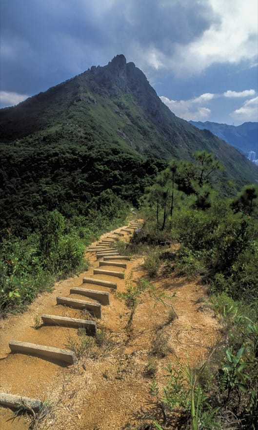
Named after former governor and keen hiker Sir Murray Maclehose, the trail opened in 1979, and remains superbly signposted and well maintained (though purists may dislike stretches with concrete steps rather than rough paths and rocks). From its start near Sai Kung, the trail runs across the New Territories, ending just above Tuen Mun. Happily, you can hike it in sections, perhaps arriving or leaving via side trails.
So if you’re inspired by the National Geographic ranking and want to hike at least some of the trail, here’s a sampling of some of the best of the ridges, coastlines and scenery en route. But even though these outings are short, all can be tough in hot weather: so unless you’re an adept at steamy summer hiking, take it easy and ensure you drink lots of water, maybe along with electrolytes.
Stage 2 Including Long Ke Wan
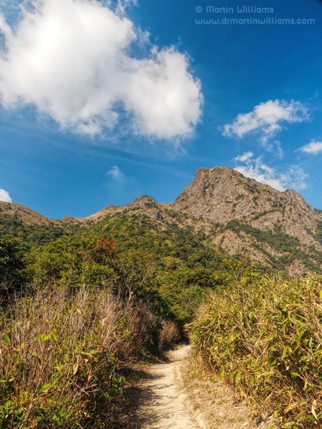
Completionists may disapprove, but unless you’re fond of plodding along roads with little change in scenery, maybe under a blazing sun, it can be well worth skipping Stage 1 of the trail, and starting a hike where it ends – at the east dam of High Island Reservoir.
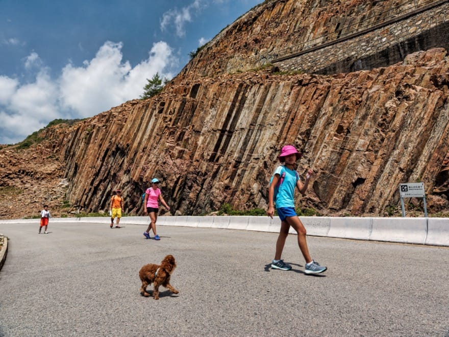
Unless you’re pushed for time, it’s well worth a look around the dam area, especially for the exposures of columnar jointed rocks that formed as a supervolcano erupted, and are the greatest attractions of the Hong Kong Geopark.
Then, start climbing the trail leading up to the north. You can enjoy grand views of the reservoir, and reach a ridge overlooking an inlet with a whitish sandy beach. With green hills, the sea perhaps a classic tropical blue, this is a glorious place.
Head down, and you can follow a trail close by the beach, passing a secluded drug rehabilitation centre and a campsite. Better still, spend some time at the beach; and if you swim, maybe look for some of the corals found in the bay.
Then, you could continue along the trail, climbing again, enjoying majestic views over Tai Long Wan to the north before winding down to a pass above Sai Wan.
Toughness *****
Getting there
Sadly, taxi is the only public transport option to the dam. From above Sai Wan, there’s a sparse minibus service to Sai Kung.
Stage 2 with Tai Long Wan
Especially in summer, Tai Long Wan is surely the area to visit along the Maclehose Trail, with expansive beaches cradled by hills and headlands, quiet hamlets, restaurants near the tideline, and a relaxed, away from it all vibe.
The Maclehose Trail drops down a footpath from the pass above Sai Wan, and crosses abandoned fields to Sai Wan. The food at restaurants here is simple, the views from them priceless. The beach is good for swimming, and you can hire gear for watersports like kayaking, paddleboarding and surfing.
You could spend much of a day here, also heading up the stream north of the village to find cascades, waterfalls, and a deep pool that’s popular with swimmers and daredevil divers who leap from the cliff above.
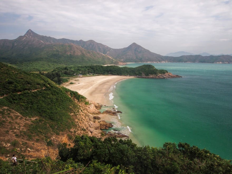
But for more hiking, cross the stream and follow the trail as it climbs a headland, before winding down to northern Tai Long Wan. Outstanding vantages make fine rest stops.
While the Maclehose Trail promptly cuts inland, the beach deserves more time. It’s magnificent. You can stroll here, seemingly far from the city. There are two beachside restaurants, and a rough track beside one that might seem unpromising yet takes you across to an even better, longer beach without a building in sight. Take care if you swim, though; there can be rip currents here, capable of tugging even strong swimmers out to sea.
A footpath runs inland, meeting the Maclehose Trail, which then climbs up and away from the area, and through hills to meet the road at Pak Tam Au.
Toughness ***** Full route ***** Sai Wan only ***** North Tai Long Wan
Getting there
There’s a minibus to the pass above Sai Wan, from Sai Kung. Or head there by taxi. Bus 94 between Sai Kung and Wong Shek Pier stops at Pak Tam Au – from where you could walk to Ham Tin, and retrace your steps.
Stage 4 Including Ma On Shan
There’s serious hill climbing along this stage of the trail – which makes for a relatively challenging day’s outing, of the kind that could lead to you being astonished anyone could cover the Maclehose Trail non-stop, let alone running it in 10 hours 58 minutes as a team of Gurkhas did in 2013.
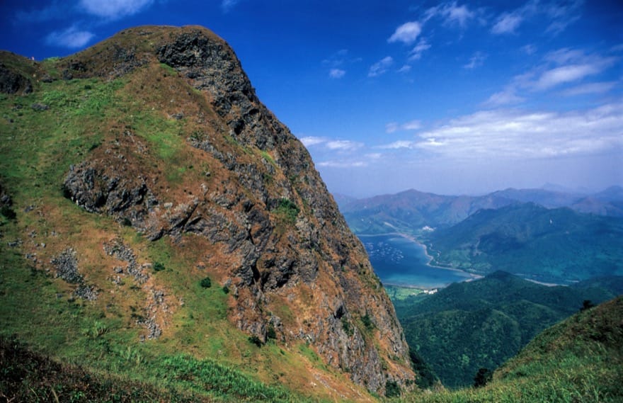
You climb steadily, with part of the route through trees. Though there’s a gentler stretch, the trail soon ascends relentlessly, up the steep eastern flank of Ma On Shan. At last, you reach the top of a ridge – a place to catch your breath, drink, admire the view. But you’re not at the top yet; there’s a side trail, then a clamber to the craggy, 702-metre summit of Ma On Shan.
It’s a tough climb, all the harder on a hot day – yet rewarding. You can savour panoramic views, including across the lower hills of Sai Kung to the east, and westwards to the broad cone of Hong Kong’s highest mountain, Tai Mo Shan: it looks distant, yet the Maclehose Trail leads there, and beyond.
The trail down is steep too, passing the peak of Pyramid Hill, and dropping to Ngong Ping, a plateau akin to a mini lost world. Here, you might leave the trail and turn north, passing Ma On Shan Tsuen and down a road to the edge of Ma On Shan new town.
Toughness *****
Getting there
Bus 99 between Sai Kung and Ma On Shan passes Kei Ling Ha.
Stage 5 Including Lion Rock
While it mostly takes the toughest options, climbing to summits or very near them wherever possible, along this stage the Maclehose Trail is relatively benign – passing below the ramparts of Lion Rock. But if you want more of a challenge, this famous landmark awaits.
Start at the old Tai Po Road, and you can enjoy a gentle walk through forest below Eagle’s Nest.
Then, enough with the gentle stuff already! Time to climb, up Beacon Hill, one of the peaks known as “dragons” that gave rise to the name Kowloon, Nine Dragons. There’s a ridge walk, with Kowloon below, and a trail downhill.
Lion Rock looms ahead: steep, rocky. If it looks too daunting, you can skirt it by sticking to the Maclehose Trail. Or turn right at a junction, for the steep scramble to the top.
Abruptly, the trail arrives at the top of Lion Rock. A cliff drops away to the south, with Kowloon below, Hong Kong Island in the distance. The city is so close, yet here you’re well above it, in a wild place.
Eastwards a little, there’s a trail plunging downhill, back to the Maclehose Trail.
Turn right once you reach the junction, and Sha Tin Pass is relatively close by. From here, you might walk down to the north, to Sha Tin; or south to the fringe of Kowloon.
Toughness *****
Getting there
Buses including 81 and 72 from Kowloon travel along the old Tai Po Road.
Stage 8 Including Ng Tung Chai Waterfalls
In an old Hong Kong hiking book, I read of old timers having fun in bringing newcomers to the summit of Tai Mo Shan and seeing them tumble into a small, concealed hole. There’s no such fun nowadays, as it’s capped by facilities that are off limits to the public, such as a weather station and a communications place.
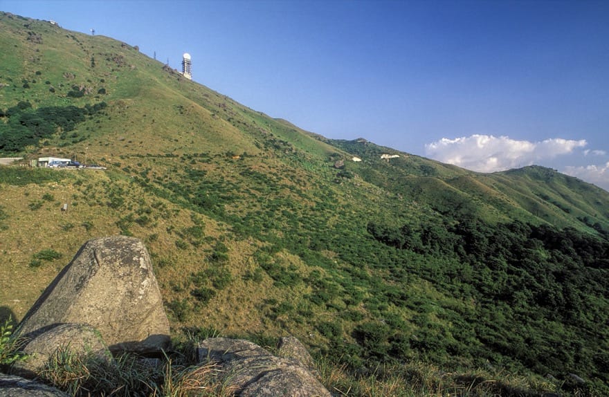
The hiking’s less satisfying too, mostly along narrow roads. But there are outstanding views across much of Hong Kong and even to Shenzhen. Providing the weather’s clear, that is! The name Tai Mo Shan might have originated from Big Misty Mountain, after the low clouds that often shroud the summit.
You can walk up from Route TWSK to the west, and pass a barrier restricting access to most vehicles to the winding road towards the top. Walking this road, you might remember chaotic scenes from January this year, when ice covered the land here, and fire crews struggled to rescue hikers and thrill seekers. On a typical summer’s day, it’s hard to imagine such conditions.
After passing close by the summit, the road is narrower, less used, and drops steeply down. Leadmine Pass lies ahead, and from it you’ve options including a walk down past Shing Mun Reservoir.
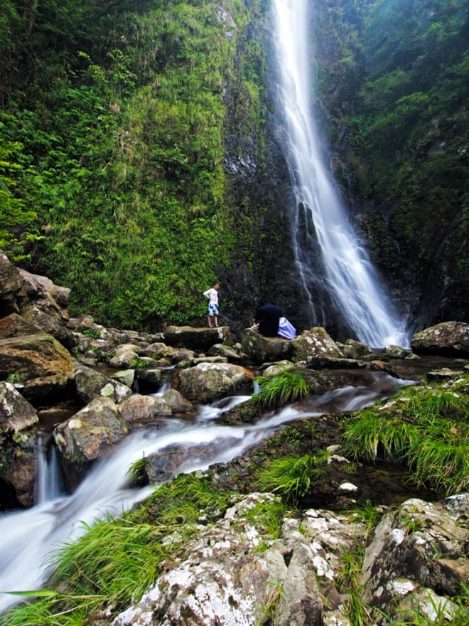
Or you could instead look for a path on the left, towards Ng Tung Chai and its splendid waterfalls. This takes you downhill, and there’s a junction where you can turn right, and into the upper reaches of a ravine. You cross a stream, then take care scrambling down over the increasingly overgrown remains of a landslide.
The scrambling section ends at the foot of the Main Fall, one of the finest waterfalls in Hong Kong. Even on hot days the spray can make the area around the plunge pool cooler than the nearby hillsides; it’s an ace place to linger.
The trail continues down the wooded ravine, zigzagging down the steep slopes. There are two more waterfalls to visit, and the trail ends at Ng Tung Chai village, below which is Lam Tsuen Road.
Toughness *****
Getting there
Bus 51 from Tsuen Wan West Railway Station heads along Route TWSK; alight at the top of the slope, and walk up the road to the right.