- This topic has 5 replies, 1 voice, and was last updated 7 years, 12 months ago by
DocMartin Williams.
- AuthorPosts
- 30 July 2016 at 8:23 am #7470
Update, 1 August 8.30pm
Typhoon Nida still bound for Hong Kong
HK Obs rating as 130km/hr max winds [10-min average], so above typhoon minimum winds
Seems indeed bound for direct hit or extremely close to one.
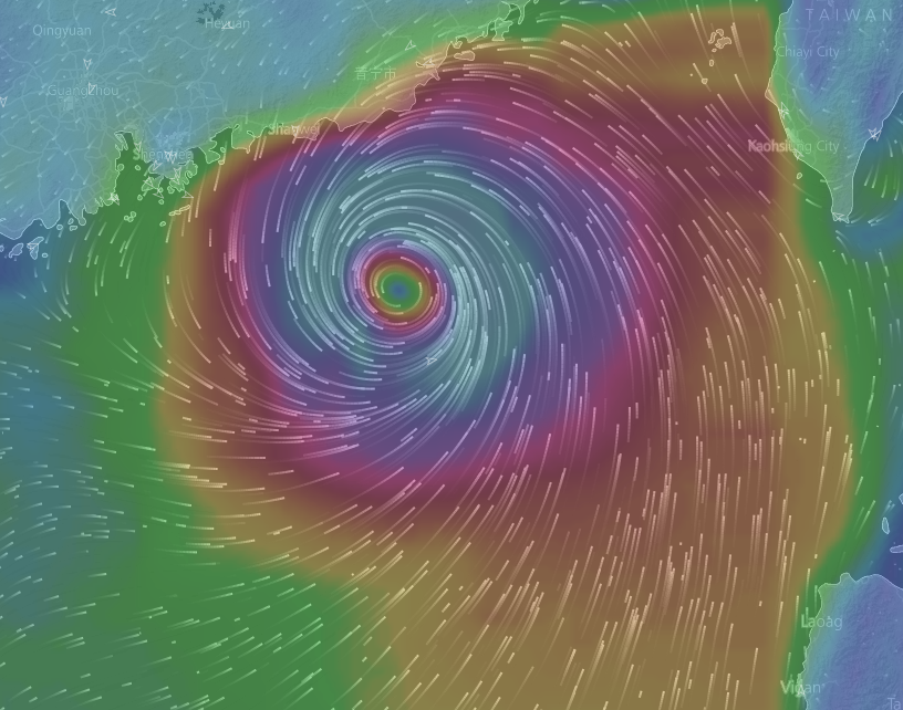
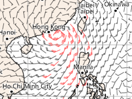
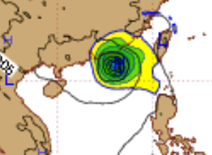
Number 8 storm signal to be in effect real soon, maybe 8.40pm; soon after can expect winds to freshen, becoming gales not long afterwards [into the more colourful areas shown here]
Animation here is fascinating to me, at least; can also visit this site and see something re waves and swell

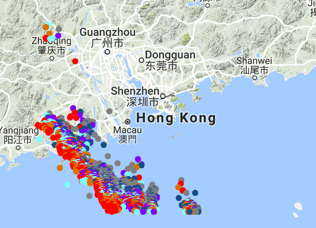
Been peaceful in HK so far; but lightning storms passed to west of us, and headed down to south

https://www.windyty.com/?20.190%2C116.873
Update, 1 Aug 10.15am:
Satellite indicates storm more organised, as expected.
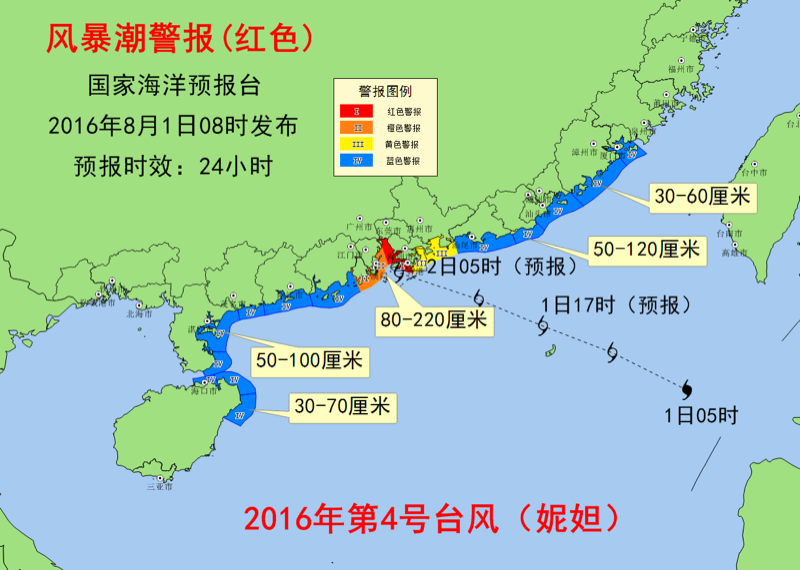
China forecasting storm surge for HK area of 80-220cm:

http://www.nmefc.gov.cn/fengbaochao/taifengfengbaochaodetail.aspx
Update, 1 August, 8.30-9am:
Direct hit looks likely; or close enough that essentially direct hit.
Still chance to make landfall enough to west that could lose some power and minimal storm surge threat; but seems more likely to be over Hong Kong or just to south, so storm surge becomes possible.
Hong Kong Observatory forecast:
According to the present forecast track, Nida will move rather fast towards the coast of Guangdong and will be rather close to Hong Kong tonight to Tuesday morning. Winds over Hong Kong will strengthen significantly around dusk today. The Observatory will consider issuing the Strong Wind Signal No. 3 around noon.
The weather will deteriorate rapidly after sunset. There will be squalls, heavy rain and rough seas. There may be flooding in low-lying areas. If Nida directly hits Hong Kong or skirts just to the south of the territory, Hong Kong will be more severely affected. In particular, if the storm surge brought about by Nida coincides with the high tide on Tuesday morning, the threat of flooding will further increase. Members of the public shall take all precautionary measures as soon as possible.
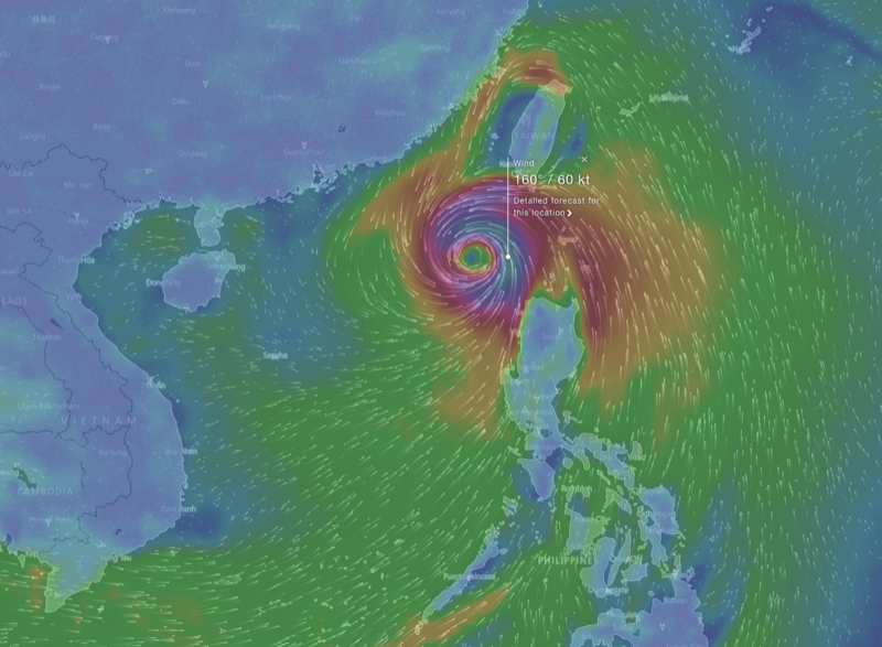
Windfield at site where you can watch animation of world winds in real time; hypnotic!

https://www.windyty.com/?17.749,120.037,6
Storm not so organised looking; which is good as far as central winds not so strong, but means pretty big radius for strong winds, rain etc
Forecasts still towards HK or just to south; the blue line to north is outlier but if takes this track will be way less of a threat

Joint Typhoon Warning Center:
ENVIRONMENTAL CONDITIONS WILL REMAIN FAVORABLE OVER THE NEXT

12 TO 24 HOURS, AND NOW UNHINDERED BY LAND INTERACTION, TY 06W IS

EXPECTED TO FURTHER INTENSIFY REACHING A PEAK INTENSITY OF 80 KNOTS.

LANDFALL NEAR HONG KONG IS EXPECTED AROUND TAU 30.
Seems timely to share this short film I put together for Hong Kong Observatory/Typhoon Committee of the World Meteorological Organization
If you watch, note in particular re storm surges: researching this, I found more records of deadly surges for Pearl River mouth area than anywhere else in east Asia, inc Philippines.
Been a long time since major surge with eye v close; and still may not happen this time. But if happens, more like tsunami with storm waves than simply extra high tide.
Film only possible thanks to James Reynolds allowing use of some unique and awesome footage from typhoon chases; some remarkable scenes inc why you should not ride a scooter in the eye of a storm!
Please share if seems worthwhile; maybe many people in HK not really aware of typhoon potential
– of course, this time may also be not so much impact; but better to know the possibilities and try to prepare…
[video:https://www.youtube.com/watch?v=8aBMgzNNrpg&index=8%5D
Update, 31 July:
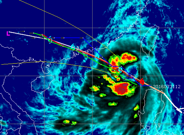
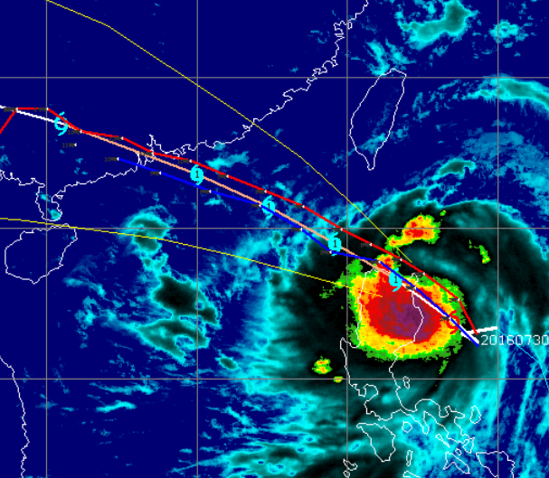
Here’s indication of where rain’s most intense, along with computer model tracks, Joint Typhoon Warning Centrer’s favoured track
via http://tropic.ssec.wisc.edu/

Original post:
There’s a low pressure to the east of the Philippines, currently organising and looking set to soon become a tropical storm. Should be named Nida.
While still early days yet, forecast models indicate it will cross north Luzon, become a typhoon, and head towards Guangdong, perhaps landing very near or even over Hong Kong (direct hit possible).
Also seen indication it could become a severe or super typhoon. Just maybe, as I write.
If it lands to east of Hong Kong, should be not too much impact: mostly northerly winds.
But direct hit or close to west would be more threatening, including with chance of storm surge.
More info to follow in this thread.
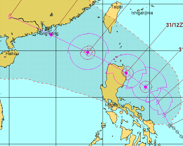
Here’s image of Hong Kong Observatory computer model forecast:

Joint Typhoon Warning Center [US Navy] info includes:
BEYOND TAU 72, ENVIRONMENTAL CONDITIONS WILL REMAIN FAVORABLE,

SUPPORTING ANOTHER PERIOD OF STEADY INTENSIFICATION. TD 06W IS

EXPECTED TO MAKE LANDFALL NEAR HONG KONG AROUND TAU 72. DYNAMIC

MODEL GUIDANCE IS IN VERY TIGHT AGREEMENT, AND THE FORECAST TRACK IS

PLACED NEAR THE MULTI-MODEL CONSENSUS, GIVING HIGH CONFIDENCE TO THE

FORECAST TRACK.
JTWC track:
 30 July 2016 at 10:49 am #8905
From SCM Post:
Hail the size of popcorn and winds gusting 100km/h swept through the city on Saturday afternoon.
As temperatures topped 33 degrees Celsius across the city, Hong Kong’s dry spell ended abruptly.
Various warnings were issued at lunchtime as thunder erupted and storm clouds rolled in, dumping rain across parts of the New Territories, Kowloon and Lantau.
31 July 2016 at 3:50 am #8906“Tidal waves from the typhoon overturned cars like so many toys”
News report on aftermath of Typhoon Wanda, which hit Hong Kong in 1962; last major typhoon to directly hit and bring a major storm surge – which can be more like tsunami than the tide gently coming in…
There’s chance of similar with Nida if it follows what seems the main forecast track – and strengthens considerably; but if it lands to east of HK and/or not so powerful could be little impact.
Worth noting, anyway, esp for anyone with place that could be hit by sea waves n flooding
31 July 2016 at 4:06 am #8907Joint Typhoon Warning Center:
TS 06W WILL CONTINUE ITS WEST-NORTHWESTWARD TRACK UNTIL IT MAKES LANDFALL NEAR HONG KONG AROUND TAU 48.
https://metoc.ndbc.noaa.gov/ProductFeeds-portlet/img/jtwc/products/wp0616prog.txt
Hong Kong Observatory:
Tropical Cyclone Nida will edge closer to the coast of Guangdong gradually tomorrow and continue to intensify. It is expected to be rather close to the vicinity of The Pearl River Estuary on Tuesday. The weather over the region will deteriorate on Tuesday and on Wednesday. There will be heavy rain, squalls and rough seas. As Nida moves away, the weather will improve over the areas of Guangdong in the latter part of this week.
http://my.weather.gov.hk/myindex.htm
1 August 2016 at 12:49 am #8908ECMWF model had been showing typhoon around here from before the storm even got organised as low
Now latest, for tonight/tomorrow morning HK time, looking like those forecasts…
 1 August 2016 at 4:07 am #8909
Experience from US showing that storms of “only” category 1 or 2 can cause significant storm surges
http://www2.ucar.edu/atmosnews/perspective/7834/hurricane-storm-surge-category-its-own
- AuthorPosts
- You must be logged in to reply to this topic.

