
香港的八號熱帶氣旋警告可能會引起爭議。
香港第8名 熱帶氣旋 警告可能會引起爭議;此號誌表示維多利亞港預計或將吹烈風。
特別是這可能意味著颶風可能很快就會隨之而來——作為眼睛 颱風 方法—這一信號可能會促使香港實際上關閉。
但是,颶風很少會隨之而來。有時,8號令發布後,除了強風和大雨之外,幾乎沒有發生任何事情——商界人士抱怨城市關閉造成了他們認為不必要的經濟損失。
最近,我在香港電台第三台聽到關於香港熱帶氣旋警告信號的討論,我通過電子郵件表示,大風即將來臨時可能會出現兩個信號:如果強風似乎不會迫在眉睫,則為8 號信號;如果強風似乎即將到來,則另一個訊號風有可能達到並超過強風強度。當時正在直播的香港天文台黃博士感謝我的建議,但表示我們已經收到了第二個信號——9號信號。但是,9號信號只有在大風吹起並增強時才會發出,而不是在大風吹襲時發出。大風開始之前;我透過電子郵件向天文台表達了這一點,這導致了以下信件。
雖然我給香港天文台的第一封電子郵件以及隨後的幾封電子郵件內容並不太豐富(如果您向下滾動,您會找到它們),但最後一封電子郵件(代理主任KH Yeung 的全面回复)可能會讓您感興趣,如果你也想知道目前的熱帶氣旋/颱風警報系統是否不足;也提到了預測雷暴時間的明顯準確性。
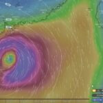
(當我發布這篇文章時,颶風查理仍在襲擊佛羅裡達州——事實證明,這是一個「好」的風暴例子,但風暴的表現並不像預測的那樣: 佛羅裡達州附近颶風意外加劇 報告了 紐約時報 [需要註冊],稱預計它將以2 級風暴的形式襲擊,風速為100 英里/小時,但在距海岸100 英里的範圍內,風暴開始增強,以強大的4 級風暴襲擊海岸,持續風速為145 級英哩每小時。 新科學家 不久之後,查理颶風的急轉彎讓科學家們感到困惑——其中提到雖然颶風強度很大,但查理的直徑相對較小。)
香港天文台署理台長楊健雄致辭,2004 年 8 月 4 日:
感謝您再次與我們分享您的觀察和觀點。
第 10 號事件相對罕見,自 1946 年以來僅發布了 13 次。罕見事件通常很難預測,特別是如果我們試圖及早做出預測。根據統計,每次8號被舉起時,它進化為10號的機會只有14%。如果我們利用這一事實,並在發出“10號”時總是預測10號不太可能出現。8、我們就對了86%的場合,這是天氣預報中的一個很高的數字。
然而,我不確定如果我們每次都嘗試透過預測熱帶氣旋的路徑、強度、大小和結構來提前做出預測,我們是否可以得分如此高或更高。即使我們每 10 次預測第 10 名就錯一次,這種情況也不太可能發生,但事實上,我們之前已經預測了很多次,這對於意外陷入颶風的公眾來說會特別危險。
這就是為什麼我們在發出8號信號時不會將其作為例行公事來指示可能的進一步信號變化,而只是在氣象條件明確時偶爾這樣做。我必須補充一點,熱帶風暴(而不是颱風)的近距離逼近沒有必要直接發生。我們已經看到風暴在香港附近增強,例如1999年的山姆在香港50公里範圍內增強為颱風。
[馬丁編輯:當我發布這篇文章時,颶風查理仍在襲擊佛羅裡達州——事實證明,這是一場風暴的「好」例子,但其表現並不像預測的那樣: 佛羅裡達州附近颶風意外加劇 報告了 紐約時報 {需要註冊},表示預計它會以2 級風暴的形式襲擊,風速為100 英里/小時,但在距海岸100 英里的範圍內,它開始增強,以強大的4 級風暴襲擊海岸,持續風速為145 級英里每小時。]
我認為我們不能對香港的大風掉以輕心。 8號令發布期間,大多數情況下都會在本港某處報告有人受傷或受損,有人因招牌、鷹架或折斷的樹枝等墜落或飛行物體受傷。有時,靠近海岸或海上的人會被海浪或湧浪奪走生命。更多的人
如果不採取適當的預防措施來防止大風的發生,他們將會受傷,更多的財產將受到損害。
現有的熱帶氣旋警告信號主要作為行動的觸發因素,有關熱帶氣旋及其對香港影響的進一步資訊將在隨該信號發出的諮詢公告中提供。社區不同部門在做出自己的應對決策時可以考慮資訊、自身業務和活動的性質以及可接受的風險程度。現行製度有足夠的彈性,可以因應社會不同界別的具體需求而採取行動。
至於雷暴警報,只要有必要就會發出警報,因此可以在任何奇數分鐘發出。然而,警告的有效期限通常是整個小時,因此警告也可能在奇數分鐘結束。
除納入預警公告外,雷暴預警由電腦自動轉換為“雷暴預警已發布,有效期至 XX:XX 上午/下午”,納入每小時公告,可在“當前天氣”部分查看香港天文台網站和撥叫天氣錄音。這聽起來可能過於精確,但為了與警告的有效期保持一致,必須如此。我們意識到了這個問題,我們的預報員已被要求嘗試在每小時 5 分鐘的倍數處發布雷暴警報,但當閃電威脅迫在眉睫時,這並不總是能夠做到。
再次感謝您的觀察與意見。
此致,
科赫
- 原始訊息 -
作者:馬丁威廉斯
寄送時間:2004 年 7 月 28 日星期三 11:14
致: khyeung.hko
主題:回覆:颱風訊號
嗨,KH:
嗯,好吧,如果你在吊掛時的預測精度是 100%
8a 或 8b(或 8 或 9)將是獨一無二的—因為您的其他預測都沒有
100% 準確嗎! (尤其是提早 7 天的。)
但是,不完全準確並不意味著預測毫無價值。
在我看來,現在的一個大問題是8號被視為自動
行動觸發因素-辦公室關閉等。這似乎很難
如果只有大風,則有必要。 (我來自英格蘭東海岸;大風
並非罕見,暴風雨也很少。)
甚至還加上“8號已經生效,但我們相信風力不會增強”
進一步”不會改變這一點。
如果有 8 號或 9 號(例如;但不同的 9 – 對於有機會的大風)
預期的增加,而不是實際上的大風吹動和增加),會
消除這一問題還有很長的路要走。
是的,它並不 100% 準確 - 但同樣,公眾必須習慣於
來自天文台的。最好根據實際情況進行預測
條件、過去的情況、經驗。
如果是上週,我會選擇 8 號。暴風雨也是,我
記得幾年前──早上8點起床,有個朋友打電話給
問會發生什麼,我說不用擔心,風暴中心在南邊
我們向西行駛,所以沒問題。
在第二種情況下,也將是 8。但是,如果方向改變
HK,改為 9。(我知道風暴可以很快改變方向,但是
如今,預報是合理的,尤其是一旦暴風雨來臨
正確移動。)
隨著颱風的臨近,看起來中心即將接近,
提升 9 個(如果有時間的話可能先提升 8 個,暴風雨不是很快;
也許直接到9)。
這樣一來,光靠大風就無法封鎖香港。 (而且,也許香港
當颱風真正來襲時會更安全—不會那麼安全
喊著“狼來了!”所以人們可能會更加尊重這些風暴,充分利用
預防措施.)
天文台有時很有趣。
也許會在下午 4 點 27 分 11 點 4456 秒之前收到雷暴警報(好吧,
不太精確,但在幾分鐘之內)。
然後,讓一位天文台人員接受媒體採訪,了解一場風暴
100公里外,以20公里/小時的速度向我們駛來,被問到還有多久
它離我們最近,他說他不知道——當我想尖叫時
「如果保持目前航向和速度的話,五個小時!五個小時 -
很明顯!!” (而且,大多數情況下,這種粗略的計算效果很好
出色地)。
此致,
馬丁
2004 年 7 月 27 日 16:22,khyeung.hko 寫道:
親愛的威廉斯先生,
林振英先生正在休假。我會讓他注意你的電子郵件
當他回來時。同時我要感謝你的
關於熱帶氣旋警報訊號系統的建議
目前的熱帶氣旋警訊系統是分級警訊系統
根據香港的風力預報,提醒民眾注意
與熱帶氣旋相關的強風威脅。
你對有兩種數字8的建議及其理由
它的背後要求我們預測並告訴公眾(透過
選擇兩個 8 號信號之一)當地風力如何
8號發布後幾個小時內將會發生變化。
不幸的是,技術現狀不允許我們
預測當地目前的風力狀況,並保持一致
準確性。因此,您建議的更改的預期好處是
訊號系統將因偶爾不準確的預測而被否定
8. 發出號碼後可能會或可能不會發生什麼
話雖如此,有時我們確實有信心是否
更高的訊號可能或不可能。在這些場合,我們給予
在與
訊號.這樣,我們就可以保持公眾對我們熱帶地區的信心
氣旋警報服務對於公眾的正確認知至關重要
對訊號的響應。
再次感謝您對我們工作這一重要方面的興趣。
此致,
楊徒步旅行
香港天文台署理台長
作者:馬丁威廉斯
寄送時間:2004 年 7 月 23 日星期五 9:37
致:CYLAM
主題:颱風訊號
嗨,CY:
剛剛聽到香港電台第三台黃博士討論颱風
訊號.
我透過電子郵件發送:
「在我看來,有警告時是否沒有必要關閉香港?
大風——尤其是如果風幾乎肯定不會變得更強
那。
如果數字 10 看起來可能的話,那就非常不同了; 10號風肯定
優點關閉。
也許可以有兩種 8 號訊號。一種帶有 10 號訊號
看起來很可能在接下來的幾個小時內。另一個看起來是10號
不太可能。
– 前者應放在後者],由企業決定
回應;對於後者[前者],應該進行更廣泛的關閉。”
黃醫師感謝我的建議,說已經有9號了
服務於此目的。
黃醫生的說法是不正確的。
為了使數字 9 達到此目的,可以舉起 8 或 9 作為
暴風雨即將來臨——不是先有 8 級風暴,也可能是 9 級風暴即將來臨,這一點很明顯
目前正在發生。 (在當前系統中,似乎可能為時已晚
辦公室在 9 號結束時關閉,因此不會觸發 8 號。)
目前,除了大風是否即將來臨之外,8 級並不能提供任何信息,但
還有更多可用資訊。是時候建立一個更好的系統了嗎? (包括
颱風的威力有多大──類似美國的颶風系統;
決策者肯定能理解其意義。)
希望您能轉發給黃醫師。
問候,
馬丁
包括熱帶氣旋在內的天氣

「颱風即將登陸香港」成為熱門話題
關於「可能的颱風」的文章,結果只是一場微弱的風暴,而洪…

香港長洲上空充滿閃電的超級電池
昨天晚上(2024年4月30日),天氣監測影像顯示出現強烈暴雨/雷暴區域-「超級單體」…
熱帶氣旋馬安向香港襲來
2022 年 8 月 25 日(晚間)更新:Ma-on 在早前預測的偏南和偏西方向上行駛;……
強颱風山竹突顯大嶼山大規模填海的危險
颱風山竹幫助表明“風暴潮”是對現代城市的威脅,而不僅僅是……

颱風飛燕警告東大嶼都會又名明日大嶼願景
你可能已經看過 2018 年 9 月來自日本的震撼畫面,包括大阪的關西……
Mad Lantau Metropolis 計劃應因風暴潮威脅而落空
從科學角度考慮,包括東大嶼都會在內的填海計劃是有勇無謀的,甚至……
香港炙手可熱,世界卻在持續變暖
雖然氣候變化長期以來似乎一直是鐵桿、擁護樹木的環保主義者的一個問題,但擔憂正在蔓延……
颱風海燕給香港的教訓
颱風海燕是有記錄以來最強的風暴之一,摧毀了菲律賓的大片土地……
預報員受益於飛往颱風的航班
除了使用計算機模型和氣象站信息外,香港天文台還使用……
香港天氣展望更暖更濕更荒涼
科學家表示,隨著全球變暖才剛剛開始,香港是時候……
颱風維森特颶風席捲香港
強颱風維森特於 2012 年 7 月 23 日至 24 日襲擊香港,颶風強度大風……

強熱帶風暴帕布
強熱帶風暴帕布看起來將經過香港,幾乎不會對其他地方造成影響……
香港颱風包括災難性風暴潮
颱風有時會在香港造成巨大的破壞和生命損失。就在幾個月後……
香港熱帶氣旋
香港可能會受到包括颱風在內的熱帶氣旋的影響。令人高興的是,颱風在附近很少見……