Support this site; gifts or treat yourself:

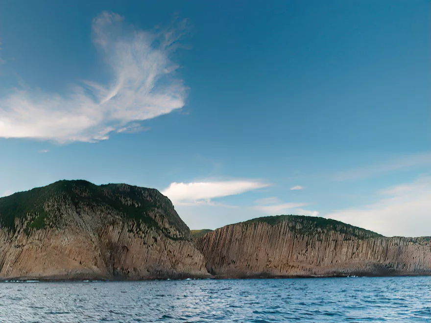
High Island and Sai Wan with columnar jointed rocks from a super-volcano
Collapse of Hong Kong’s Last Great Volcano
Around 140 million years ago, during the Early Cretaceous, a grand volcano dominated the landscape in eastern Hong Kong. Its northern slopes rose above present day Tai Long Wan on the Sai Kung Peninsula; its southern slopes reaching the Ninepin Group or further. We do not know the volcano’s height, for it was destroyed during a mighty implosion, yet it probably had steep slopes, with more than one peak formed by eruptions from several vents.
This volcano had grown during the fourth and final phase of volcanic activity in Hong Kong. The first phase had been in the northwest, resulting in volcanic rocks found near Tuen Mun, but over the course of around 25 million years, the centres of volcanic activity shifted towards the southeast.
The volcanic activity began as two crustal plates collided beneath present day Hong Kong. The southern plate moved north, and slipped – was subducted – under the other, continental plate. As the crustal material descended and heated, its rock melted and formed magma that pushed upwards to form volcanoes along the continental edge, rather like the Andes today. More material was added to the continental margin, and the original volcanoes fell silent. The crustal boundary evolved, with subduction giving way to more lateral movement by the fourth and final phase of volcanic activity.
The magma was thick, viscous material, which released pent up gases as it neared the surface, resulting in explosive eruptions of incandescent ash that formed tuffs found in many parts of Hong Kong.
Collapse and a Colossal Eruption
The collapse of the great volcano of southeast Hong Kong probably began with one or more huge eruptions. Prior to these, earthquakes shook the ground, as magma surged upwards within the volcano. Nearing the surface, the magma began releasing its dissolved gases, powering explosions that blasted liquid rock apart, and sent an ash cloud towering skywards. If it was night, there may have been a stunning light show, with lightning bolts flashing through the cloud. Pyroclastic flows – like incandescent avalanches – may have raced down the volcano’s slopes, incinerating and obliterating vegetation and animal life,
The ash darkened the sky over Hong Kong, and rained down over a wide area. Eventually, as the eruptions continued, the pressure within the volcano fell. The volcano was already weakened by cracks and faults, and now became unable to bear its own weight.
Suddenly, the great volcano collapsed, with its middle part crashing down towards the magma chamber. Now came the final, cataclysmic eruption, which gave rise to the rocks at the heart of the Geopark.
More magma exploded and was blasted apart. The explosions shattered rock into dust. The plume of ash may have been even greater, reaching perhaps 30 kilometres or more high, with so much ash sent into the atmosphere that it cooled the global climate for the next year. Yet much of the ash was trapped within the newly formed basin – the caldera.
This ash formed a roughly oval layer, around 25 kilometres long and 10 kilometres wide, and up to 400 metres deep. An estimated 70 square kilometres of ash were laid down in this one event, six times the volume blown skywards when Krakatau exploded in 1883. This volume would place the eruption at the higher end of ranking 6 on the Volcanic Explosivity Index, which has a scale from 1 to 8. This would rate it as a “colossal” eruption.
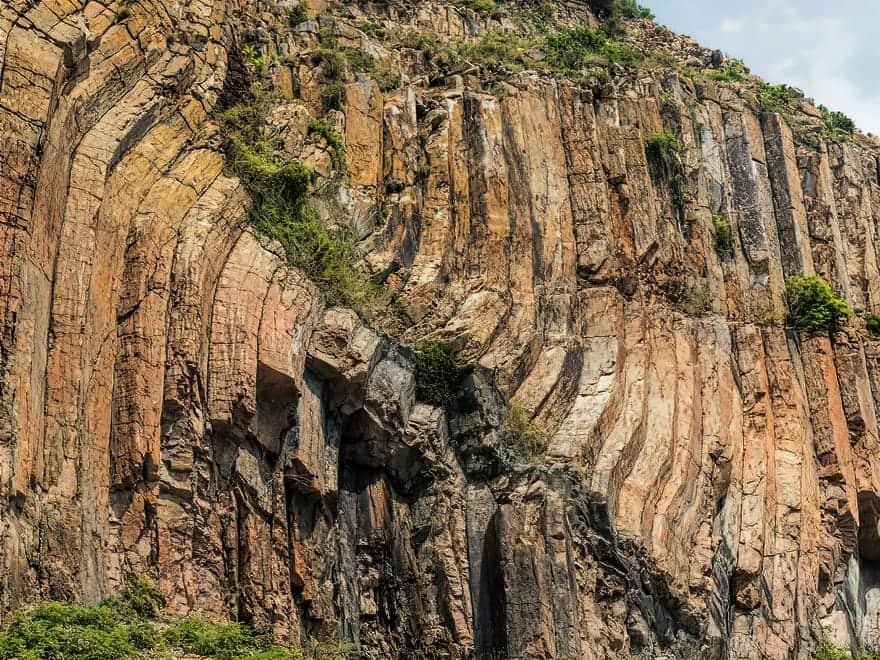
Initially, the ash was so hot that it fused to become rock, known as tuff. As it cooled, vertical fractures developed, leading to the striking hexagonal columns seen today.
This was evidently the last major eruption in Hong Kong, bringing to an end the four phases of volcanic activity that helped form much of the landscape.
Hexagonal Columns
Hexagonal columns are known in volcanic rocks elsewhere, sometimes forming well-known landmarks, such as Giant’s Causeway in Northern Ireland, and Devil’s Tower in the US. But Hong Kong’s High Island Formation is the world’s most extensive columnar-jointed tuff.
In Hong Kong, the hexagonal columns are up to 30 metres high, and can be over a metre wide. Exposures of the tight packed rock columns are today among the most striking features of the Sai Kung Peninsula.
Some of the best exposures are near the eastern end of High Island Reservoir. Just below the east dam, there is a small cliff formed of the close-packed columns. Here, instead of being dead straight, the columns are kinked, indicating slumping as the ash layers cooled to become tuff.
Southeast of this east dam, the scenery is more spectacular. A small headland has cliffs of jointed tuff plunging to the sea. Just offshore, Po Pin Chau is an islet fashioned from the rock columns.
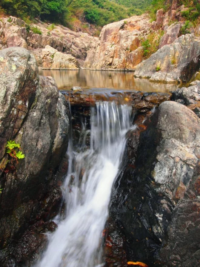
Waterfalls and a Stone Trail
North of the reservoir, the Kap Man Hang stream has carved into the tuff, cutting a steep valley from the Luk Wu plateau to Sai Wan. Below the abandoned Luk Wu hamlet, there is a series of fine waterfalls and plunge pools. Adventurous hikers follow a rough, mostly rock trail beside the stream here, sometimes climbing the waterfalls.
History
Hakka – “guest people” – farmers settled in Hong Kong from around the 17th century, fleeing famine and persecution further north. With the best farmland taken by Cantonese people, they mainly occupied hilly areas such as the Sai Kung Peninsula. With its hilly terrain, the Sai Kung Peninsula has proven a tough area to settle. In the 1600s only three villages were reported in the whole Sai Kung area: they were called “snakes” as they spoke a dialect that was incomprehensible to others.
Even by 1960, a gazetteer recorded only 66 villages with around 3000 residents on the peninsula and nearby islands; just 16 of these villages were in the eastern peninsula. Partly as construction of the High Island Reservoir in the 1970s reduced water supply for several areas, villages in the eastern peninsula are now mostly abandoned.
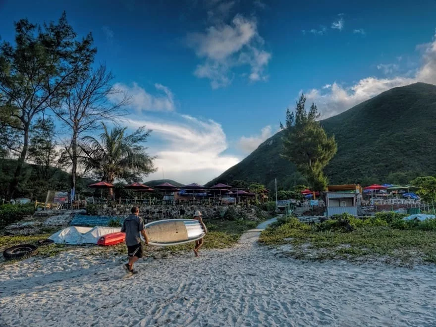
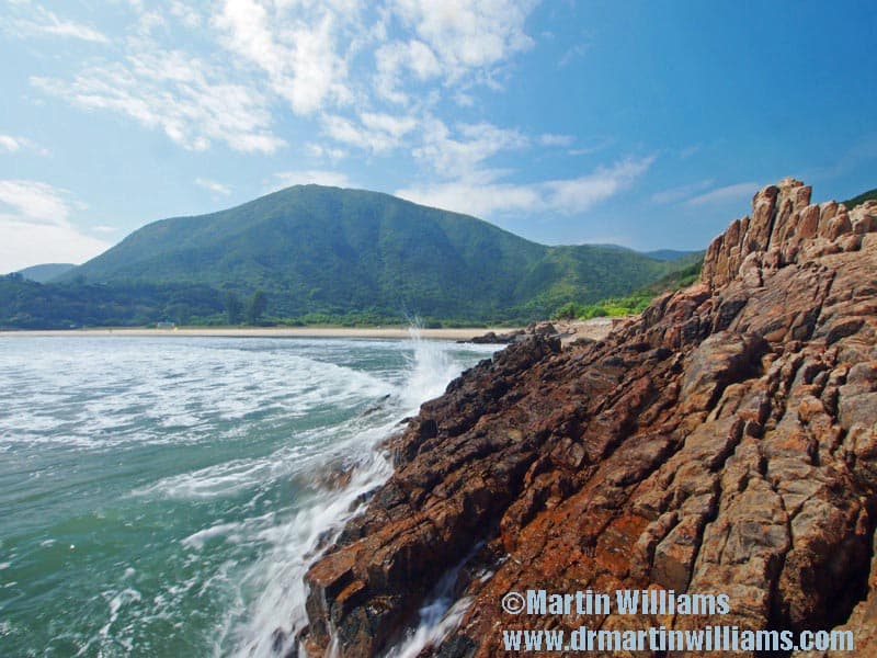
Sai Wan is among the few remote villages that have retained their rural character, whilst becoming destinations for rural tourism. The “tourists” – overwhelmingly Hongkongers – visit to enjoy the superb hiking trails, as well as to snorkel, dive, take photographs, watch birds and other wildlife, in an area that seems far from urban Hong Kong.
In the 1970s, roads were built to near the eastern tip of the peninsula, to help with construction of High Island Reservoir. Access to these remains strictly controlled, however, as only vehicles with special permission can pass east of a barrier at Pak Tam Chung. This helps maintain the Sai Kung Peninsula’s beauty and value as an outdoor recreation area.
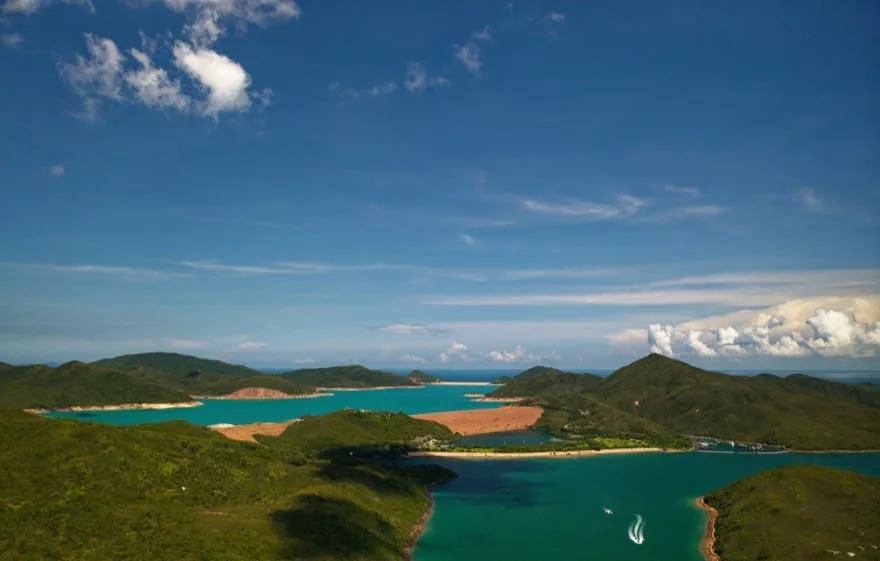
High Island Reservoir
High Island Reservoir was the last and grandest of Hong Kong’s reservoirs, built in the 1970s to try and meet the fast growing water demands of the expanding city and associated industries. Like Plover Cove Reservoir in the northeast New Territories, which was completed in 1968, it was built on the coast rather than within a stream valley: two dams were built to connect High Island to the peninsula, and so form a reservoir in the former Kon Mun Strait.
Before work could begin on the main dams, two cofferdams were built, to hold back the sea and create dry land behind them. These were also retained as protective structures, While the western dam faced the sheltered waters of Port Shelter, the east dam was exposed to the South China Sea – and to the full force of waves crashing inshore during typhoons. These waves could be up to 12 metres high, and to counter them, the engineers used a new South African invention: dolosse.
Dolosse are huge concrete blocks – those at High Island Reservoir weigh 25 tonnes each – and are shaped rather like a letter “H” with one side twisted by 90 degrees. They were invented in the 1960s by a South African engineer who wanted to protect a harbour using shapes that would interlock yet could be “sprinkled” into place. He thought of dolosse – which till then were South African children’s toys made of goat or sheep knucklebones, and when he used the concrete shapes to armour his breakwater they indeed absorbed the force of waves: “When high seas hit them, the water all but disappeared—no slaps like thunder, no geysers in the air,” wrote John McPhee in Giving Good Weight.
Some 7000 dolosse were used to armour the eastern cofferdam.
With the cofferdams in place, work began on the main dams, initially involving clearing the construction sites to the bedrock. Once completed, the east dam was 486 metres long and 106 metres high; the west dam was 753 metres long and 101 metres high. The High Island Reservoir scheme also included 40 kilometres of tunnels, including a tunnel from Pak Tam Chung to a treatment works in Sha Tin. Construction began in 1971, and the reservoir opened seven years later. It catches and stores rain falling on an area of 70 square kilometres over Sai Kung, Ma On Shan and Sha Tin, and can store 281 million cubic metres of water.
Ten villages were affected by the project – some were submerged, others had far less water available for agriculture. Though the government relocated 300 to 400 people to Sai Kung, and to Sam Mun Tsai New Village, and paid some compensation for land, the villages were unhappy as the project impaired their traditional rights and the compensation was only a fraction of the market value.
Plants and shells were found as the construction sites were excavated. There were logs and nuts that were over 40,000 years old, showing there was then a tropical oak forest here. There were also remains from 8000-year old mangrove swamps.
Flora and Fauna
After the Second World War, work began on reforesting hillsides that had been cleared during centuries of human occupation. Sai Kung village communities were especially cooperative, and by 1952 the Sai Kung Peninsula was being transformed into one of Hong Kong’s most beautiful forest areas.
A key species planted was Chinese Red Pine Pinus massoniana, but by the 1970s many of the pines were killed by nematode parasites carried by beetles. Broadleaf trees have grown in their place, so there are now expanses of young woodland with native species such as Chinese Tallow Tree Sapium sebiferum, Machilus species, Fragrant Litsea Litsea cubeba, Lance-leaved Sterculia Sterculia lanceolata and Ivy TreeSchefflera heptaphylla.
The grassland, scrub and secondary woodland are home to fair numbers of larger animals such as Wild Boar, Masked Palm Civets, Small Asian Porcupines Hystrix brachyura, Leopard Cats Felis bengalensis and Burmese Pythons Python molurus bivittatus. This is not, however, a perfect sanctuary, as shown by reports of people from mainland China uprooting and stealing Buddhist Pines Podocarpus macrophyllus from the Sai Kung Peninusula.
Marine life is diverse, including hard corals – which in the relatively clear, oceanic waters of Long Ke Wan are found at depths down to ten metres.


