Support this site; gifts or treat yourself:

HK Geopark along the Tolo Channel: Ma Shi Chau, Lai Chi Chong and Bluff Head
Ma Shi Chau: an Introduction to the Hong Kong Geopark
Ma Shi Chau is one of the best, most easily accessed places to visit for an introduction to the Hong Kong Geopark, and an overview of the geology of the eastern New Territories. The island itself is unprepossessing – just 1.5 kilometres long, rising to 114 metres, lacking villages or striking scenery, and with an unfortunate name that means “Horse Excrement Island”.
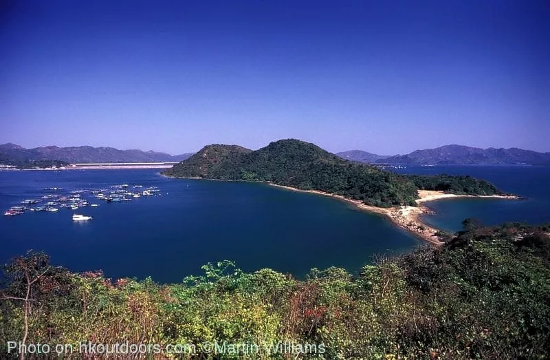
Yet Ma Shi Chau has interesting geology, which has led to the island plus nearby Centre Island (A Chau), Yeung Chau and an unnamed islet being established as the Ma She Chau Special Area. Plus it’s in a region akin to a geological amphitheatre, with hills including Ma On Shan to the south, Hong Kong’s highest mountain – 957-metre Tai Mo Shan – to the west, and Wong Leng capping the Pat Sin Leng range to the north.
The oldest rocks in view include those of Ma Shi Chau itself. They’re sedimentary, laid down in a coastal environment up to 280 million years ago. The youngest rocks in view are also sedimentary – and though their sand and cobblestones evidently originated from a semi-arid flood plain, they form much of the ridge atop the steep Pat Sin Leng escarpment.
Over time, rocks tend to build up in layers, with younger rocks forming above older rocks. So you might expect that from the shore of Ma Shi Chau to the tops of the hills, the rocks become progressively younger. This is not the case, for earth movements and intrusions and eruptions of igneous rock as volcanoes formed have made the geology of the area complex.
Earth Movements and Volcanoes
These earth movements, and the volcanoes, were chiefly associated with the Lianhuashan Fault Zone, which is like a great suture in the earth’s crust, leading from Hong Kong northeast to near Shanghai. It perhaps marks the boundary where two of the earth’s plates collided and fused together during the Proterozoic, the eon between 2500 and 543 when life began to flourish, but before the Cambrian period, when the evolution of complex life forms began in earnest.
Faults occur where rock masses crack and move past each other – with one side sometimes moving up relative to the other, and sometimes with sideways movement. Many of Hong Kong’s main faults run southwest – northeast, parallel with the Lianhuashan Fault Zone. They include the Tolo Channel Fault, which is actually a set of faults that lead from around Tsuen Wan and Lai Chi Kok, through the Sha Tin area, and on through Tolo Channel towards Mirs Bay.
Faults are often lines of weakness, subject to erosion, and the eastern Tolo Channel Fault was formerly eroded by a river, but much of the river valley flooded as sea level rose at the end of the last Ice Age.
The Tolo Channel Fault also helped magma surge upwards to form volcanoes. Today, volcanic rocks dominate the Hong Kong landscape, forming mountains including Ma On Shan, Tai Mo Shan, and the Pat Sin Leng range beneath the cap of sedimentary rock. There are also granites and related igneous rocks, which formed as magma cooled deep below the surface.
The east and especially northeast New Territories are unusual in Hong Kong as sedimentary rocks are relatively plentiful here. East of Ma Shi Chau, at Bluff Head, the oldest rocks in Hong Kong are sedimentary in origin. Closely allied sedimentary rocks form much of the Hunchbacks, in front of Ma On Shan, but here they have been baked – metamorphosed – by heat from igneous intrusions. Further east still, the fine-grained mudstones of Tung Ping Chau are the youngest Hong Kong rocks.
Bisected by faults, sometimes contorted by immense pressure, eroded into hills, valleys and twisting coastlines, the varied rocks form a mosaic that tells much of the story of how the land and islands we know as Hong Kong formed.
A Visit to Ma Shi Chau
Ma Shi Chau is readily visited, though its rocks are best seen at low tide, when more outcrops are exposed. It may also be advisable to check tide forecasts beforehand as very high tides might make it hard to cross the tombolo from Yim Tin Tsai.
You can walk to Ma Shi Chau from Sam Mun Tsai New Village, at the north of Yim Tin Tsai island. The north tip of Yim Tin Tsai, and the small peninsula it is linked to by a concrete causeway, are underlain by Tai Po granodiorite. This granite like rock formed deep underground,
The path leads south from the village, and climbs a little – crossing a fault line, south of which Yim Tin Tsai is dominated by tuff, which formed from ash and other debris that were blasted from explosive volcanoes. They date from around 180 million years ago, during the first of four main volcanic episodes that affected Hong Kong.
The path leads through a cemetery, and swings eastwards, climbing a little and affording excellent views towards the Pat Sin Leng range and Plover Cove Reservoir. The path then drops, to a tombolo linking Yim Tin Tsai and Ma Shi Chau.
Tombolo
A tombolo is formed from sediments such as sand, which are swept round an island by waves, and deposited in a line that links the island to the nearby mainland or a neighbouring island. Typically, tombolos are short – like the tombolo to Ma Shi Chau, which is around 100 metres long. But some are sizable, and thousands of years ago the world’s largest tombolo linked Sri Lanka and India across the 53-kilometre wide Palk Strait.
This tombolo is sandy, with boulders and hardy plants such as screw pines along the top.
To Rocks Before Dinosaurs
Just across the tombolo is the first information sign of the Ma Shi Chau Nature Trail. This tells of an unconformity, where the Yim Tsin Tsai tuff meets the sedimentary rocks that make up the rest of Ma Shi Chau. “Unconformity” means the younger rocks – here, the tuff – are not laid down in a layer that follows the earlier pattern of deposition. Instead, the earlier rocks may have been tilted, eroded, and then covered.
The sedimentary rocks by this unconformity are pinkish siltstones, which an ammonite fossil suggests are Lower Jurassic – around 200 to 175 million years old. Ammonites are extinct sea creatures, similar to the Nautilus that survives today. Other ocean life of the Jurassic included large marine reptiles, while land areas were ruled by dinosaurs, and pterosaurs soared through the air. Yet Hong Kong has only few, small outcrops of sedimentary rock, and no large animal fossils have been found. As other areas of the Geopark show, in Hong Kong the Jurassic was not the age of the dinosaurs, but of volcanoes.
Elsewhere on Ma Shi Chau, the rocks are older, from the Permian period (299 to 251 million years ago) – when early reptiles were evolving, and bony fishes came to dominate the seas. Again, no large animal fossils of this age have been found in Hong Kong, but fossils have played key roles in dating the rocks.
The nature trail runs southeast, alongside a pleasant, sandy beach, then turns to follow the southeast shore of Ma Shi Chau, where there are small beaches of pebbles and seashell fragments, and outcrops of sedimentary rock. At intervals, there are more information boards, chiefly on points of geological interest. Some of the geological features the boards tell of aren’t very clear to the untrained eye – for instance, the unconformity is not striking – but others are obvious, and it’s a pleasant walk, with good views south over Tolo Harbour.
Fossils as Clues to the Past
One of the boards is at the southeastern point of Ma Shi Chau, and notes that the rocks here are the oldest on the island – in turn making them among the oldest rocks in Hong Kong. As with the Jurassic outcrop, fossils have been important in dating Ma Shi Chau’s rocks.
Ma Shi Chau’s Permian fossils include bivalves such as scallops; brachiopods – which are similar to bivalves and also known as lamp shells, crinoids – also known as feather stars, because of the waving tentacles they use to catch food; bryozoa – which resemble corals; and a species of coral. However, these fossils are not abundant: a casual check of the rocks reveals no signs of fossilised shells or tubes. Together with plant fragments found on Centre Island, just to the south, these fossils helped geologists to determine that the sediments formed along a coast, perhaps mainly on tidal flats.
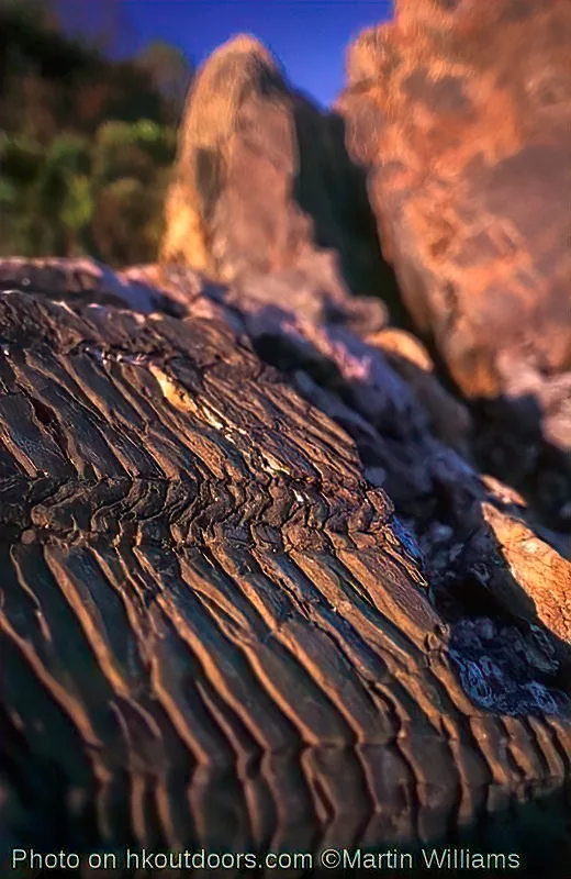
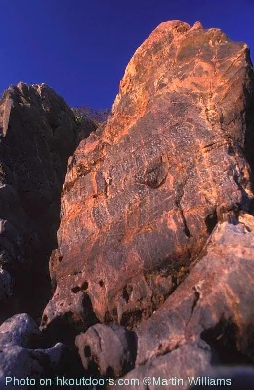
The Ma Shi Chau rocks are mainly mudstones, siltstones and rather coarser grained sandstone, often tinged pinkish or reddish by iron oxides. Though laid down in near horizontal layers, the rock beds have been tilted and contorted. At the island’s southeast point, the rock layers dip steeply into the beach. The rocks also bear witness to a later phase of folding – exposed surfaces of siltstone display kink-banding, which looks like someone took a rake and scored parallel lines across the surface of clay.
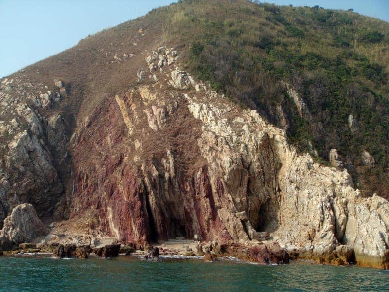
Quartz Veins – and a Dragon
Further along the trail, there is a cluster of pinkish rocks with whitish veins of quartz criss-crossing their surfaces. The quartz crystallised from a hot solution carrying silicon dioxide, which was squeezed through cracks in the rock. Quartz is a hard mineral, and the veins have proved more resistant to erosion than the rock, forming raised latticework on boulders on the beach.
Onwards, another feature created by differential erosion even has its own local name – Lung Lok Shui, which might be translated as Dragon Diving Into the Sea. A band of shale cuts across the beach, its layers tilted so they plunge almost vertically down. This dark, fine-grained rock is harder than the rock layers above and below it, so stands a little taller, in places reaching perhaps a metre above the beach on either side.
The band has been eroded unevenly, forming a low, zigzag ridge – which to some imaginative people recalls the back of a dragon, with its armoured plates. While distinctive, it’s far smaller than another Lung Lok Shui in the Geopark – on the west coast of Tung Ping Chau.
Tight Folding
Near the northeast tip of Ma Shi Chau – at the end of the nature trail – the exposed rocks are tightly folded – giving some indication of the power of the earth movements that have affected the Hong Kong area.
Sam Mun Tsai
At Sam Mun Tsai, there are boards telling of the village’s history, as well as a small museum – the Fisherman’s Culture Gallery. The original Sam Mun Tsai was on a nearby islet, Pak Sha Tau, which lies off the tip of the Lo Fu Wat Headland, southwest of Bluff Head. There was a tiny islet between Pak Sha Tau and the mainland, resulting in three entrances – sam mun – to Plover Cove.
When Plover Cove Reservoir was built in the early 1960s (see below), the villagers were resettled, to Sam Mun Tsai New Village on Yim Tsin Tsai. They were joined by some fishing families from Ko Lau Wan and Grass Island (Tap Mun), at the mouth of Tolo Channel.
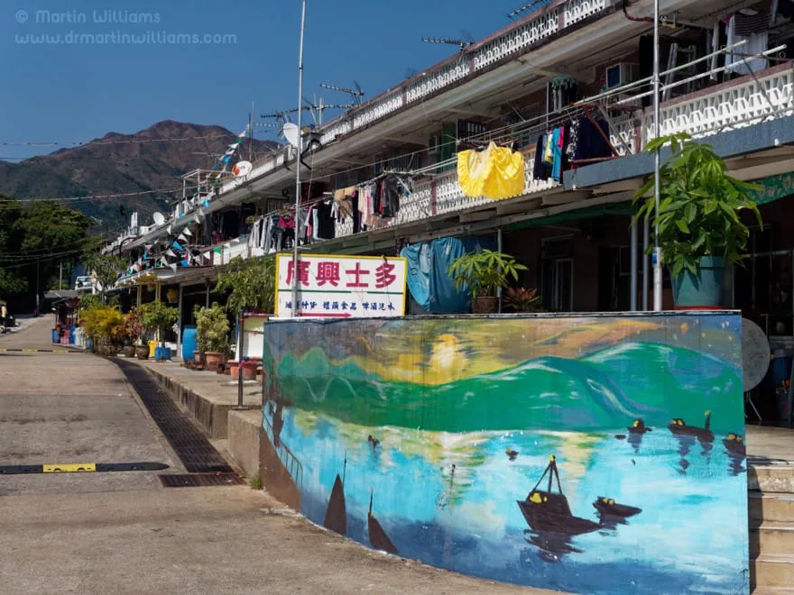
Today, around 1000 people live in Sam Mun Tsai. Some still make a living from fishing and fish farming, and as you walk through the village you can see fish drying, as well as likely hear the clack of mahjong tiles.
Egrets and Eagles
There is an egretry on Centre Island. However, numbers of egrets breeding here plummeted from 74 nests of three species of egrets and Black-crowned Night Herons Nycticorax nycticorax, to just nine nests of two species the next year: it seemed that, for some reason, most birds had moved to Penfold Park in nearby Sha Tin.
Other birds that may be seen in this area include White-bellied Sea-Eagle Haliaeetus leucogaster. Watch overhead, and you might see an eagle cruising along the hillsides, differing from kites in having a shorter, blunt tail, wings held in a slight “V” rather than horizontally and, if adult, a white body contrasting with grey upperwings. This eagle can be found throughout the Geopark, with a few pairs breeding on trees along quieter stretches of coast.
Hong Kong’s “Dead Sea”
In The Sea Shore Ecology of Hong Kong, Brian Morton described the inner reaches of Tolo Harbour as, “to all intents a dead sea”. This area had been rich in life – with flocks of ducks in winter, fringing mudflats and mangroves, corals on rocks. Yet after the advent and growth of new towns at Sha Tin and Tai Po, the enclosed Tolo Harbour became severely polluted, killing much marine life.
There have been improvements in sewage treatment, as well as massive decreases in livestock waste entering streams around the harbour, and the water is rather less polluted today. Even so, filth and algae typically make the water turbid – almost opaque. Indeed, even at relatively shallow depths the water is so dark that parts of Tolo Channel now host black corals, which elsewhere in the world are only found at considerable depths, below where most light can penetrate in clean water. Despite their name, these corals – which have tree like forms, and are related to urchins – can be brightly coloured.
Towards the mouth of Tolo Channel, where the water is cleaner, there are also hard corals.
Walking the Ma Shi Chau Nature Trail, it’s clear to see that shellfish are plentiful, as shell fragments cover small beaches. Digging a little into silt and pebbles, you can readily find small clams.
Lai Chi Chong
Lai Chi Chong is on the southern coast of Tolo Channel. Named after three huge lychee trees that once grew here, the village is set by gently sloping land beside an inlet, cradled by hills. There are old fields, a fung shui wood just above the village, and woodland and scrub on the hills.
From Lai Chi Chong eastwards to Long Harbour and across to Grass Island (Tap Mun), the rocks are mainly tuff, from eruptions around 142 million years ago. Westwards, the rocks are considerably more varied. They include rhyolite – a fine grained volcanic rock that was probably intruded into tuff: squeezed in place as molten rock, then cooling quickly so the crystals are tiny.
Most of the headland just west of Lai Chi Chong is made up of a sedimentary rocks mixed with some tuff. These sedimentary rocks formed from material eroded from volcanoes, and deposited in a lake. Fossil tree trunk remains and fragments of plants including conifers have been found in this rock, indicating it formed in the Early Cretaceous. At this headland’s western tip, near Sham Chung, there are small outcrops of Permian and Early Jurassic sedimentary rocks. These are closely related to rocks at sites such as Ma Shi Chau on the opposite shore of Tolo Harbour.
At the shore of Lai Chi Chong, there are exposed rocks that are banded, and strongly folded – reflecting the powerful earth movements that have affected Hong Kong.
Because of the rocks and rock formations, Lai Chi Chong has been designated a Site of Special Scientific Interest (SSS). Also of note here is a small stand of mangroves, at the mouth of a stream. Mangrove species found here are River Mangrove Aegiceras corniculatum, Kandelia Kandelia candel and Grey Mangrove Avicennia marina; animals include Buddhist crab Tmethypocoelis ceratophora and the fiddler crab Uca chloropthamalus.
Bluff Head
Reached only by a boat ride or a long hike from Plover Cove Reservoir, Bluff Head is among the most remote places in Hong Kong. It is also one of the most geologically significant sites, with the oldest rocks in the territory.
These rocks are from the Devonian period, 416 to 359 million years ago. The Devonian has been called “The Age of Fish” – as there were major developments in fish, including the first appearance of bony fish. But there were other major advances in life, too: forests first grew on land, and some fish evolved legs, and began walking on land as tetrapods.
There are fossils in the rocks at Bluff Head, however they are far more important for dating the rock and indicating where it formed than for helping to tell the story of life. These fossils include bivalves, gastropods, crinoids and plants – which show that rocks of the Bluff Head Formation along the north shore of Tolo Channel are from Early to Middle Devonian in age. There are fish fossils, such as fragments of placoderm plates.
Placoderms were armoured prehistoric fishes. During the Devonian, they came to dominate both the seas and freshwater ecosystems – though not one species survived a mass extinction at the end of the period.
Hong Kong’s placoderms were likely the top predators in rivers and lakes on an extensive alluvial plain. This plain was not part of any landmass that would be recognisable to us today: the part of the world that we know today as Hong Kong was at the margin of a crustal fragment known as the South China Block, while most land on earth was linked in a supercontinent, Gondwana.
The Bluff Head Formation rocks are sandstones – some laid down by water, some in wind-blown dunes; together with mudstones, and coarsely grained conglomerates. Today, they are wildly contorted: cliffs at Bluff Head reveal layers plunging steeply into the sea, as well as tight folds.
As well as the folding, earth movements have produced faults here. One of these runs almost along the coast, where there are narrow outcrops of younger, Jurassic sediments. Another fault cuts through Bluff Head itself, and on the north of the headland there are Early Cretaceous sediments. Though roughly 250 million years younger than the predominant rocks of Bluff Head, these were likewise laid down on an alluvial plain – yet by this time, a regional map would have been far more familiar, with Hong Kong part of Asia. Albeit, that is, Asia without India – for the Indian plate was yet to collide with Asia, and so form the Himalayas.
Plover Cove Reservoir
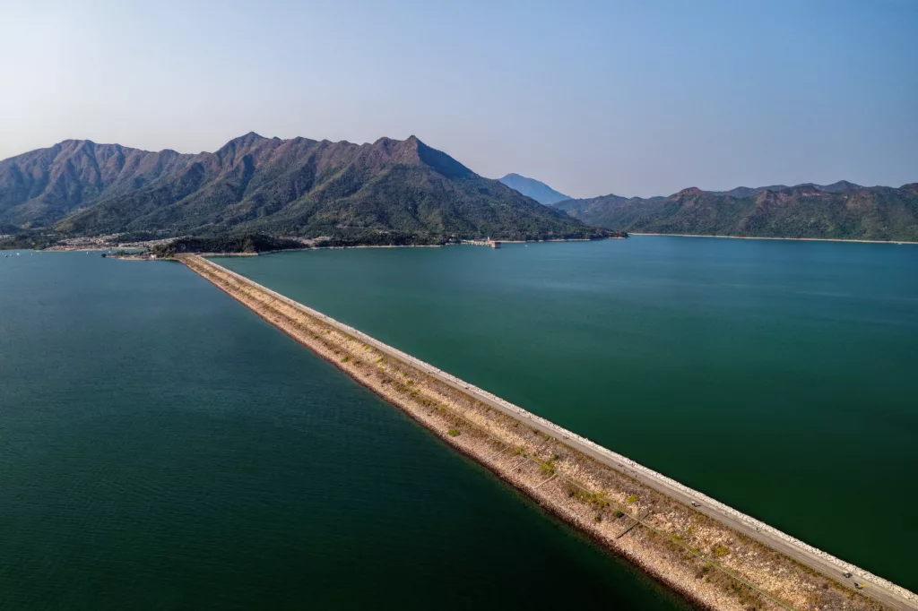
Hong Kong’s second largest reservoir, Plover Cove Reservoir, now occupies a former bay that lay to the west of Bluff Head. The idea for the reservoir originated in the late 1950s with T.O. Morgan, who was Hong Kong’s director of water supplies.
At the time, Hong Kong’s available land for reservoirs had been largely used, yet the growing city was demanding ever more water. A radical solution was needed. Mr Morgan came up with just such a solution as he swam in Plover Cove: enclose the bay to form a freshwater reservoir. This would be the world’s first reservoir in an area that was originally sea.
The project began in 1961, and was aimed at creating a reservoir holding 170 million cubic metres – more than three times the capacity of all the existing reservoirs at the time. It involved a two-kilometre dam from the Tai Mei Tuk Peninsula to the islet of Pak Sha Tau, and a smaller dam linking this to a peninsula to the east, as well as extensive catchwater systems, Lower Shing Mun Reservoir, and pipelines to Sha Tin, where a treatment works was built.
The reservoir was opened in 1968, and from 1970 to 1973 the dams were raised, increasing the capacity by 60 million cubic metres. Today – following construction of High Island Reservoir in the 1970s – Plover Cove is Hong Kong’s largest reservoir in terms of area, and second largest by volume. It is now important for storing water piped into Hong Kong from mainland China.


