
Even before it really formed, there were forecasts indicating Typhoon Ragasa – as it is now known internationally – would be powerful and could threaten Hong Kong. This remains the case; and here, some updates as Super Typhoon Ragasa approaches Hong Kong; set to be closest early 24 September.
Even passing around 100km to the south, it looks set tol cause serious storm surge – somewhat like a tsunami, with powerful waves. Wind impacts seem certain as well, given wind speeds are reaching hurricane force and above, with gusts well above hurricane force. Plus, may be intense rainfall. For some info on impacts of historic typhoons in Hong Kong, see post on this site: Hong Kong Typhoons including Calamitous Storm Surges.
Info on Damage Caused by Super Typhoon Ragasa
Page on this site: Widespread Impacts of Super Typhoon Ragasa including Hong Kong
10.15am, 24 September: Super Typhoon Ragasa ca 115km ssw of Cheung Chau, still strong in sw Hong Kong with storm surge almost peaking
Ragasa is passing just far enough to the south that Hong Kong has been spared the worst of potential impacts. However, there is still significant storm surge, which can be made worse by onshore winds and waves. Ragasa is nearing Macau (will likewise pass a little to the south, north eyewall winds surely fierce there, pushing waves onshore); and Macau has a more serious storm surge occurring.


6am, 24 September: Super Typhoon Ragasa just over 100km from Hong Kong, ferocious winds, storm surge looking a real threat
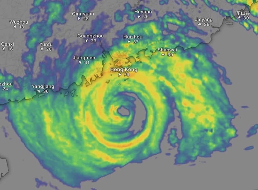
Well, I did sleep a bit; but woke with real noisy winds blasting outside. Ragasa is now nearing its closest approach to Hong Kong, with winds at Waglan in the southeast well over hurricane force [118km/hr], wind speeds elsewhere approaching this, and gusts to well over 150km/hr – I noticed just over 200km/hr at Stanley.
Still has a “great” structure as shown on radar; could be around 100km at closest approach. Centre is now around 110km south of Cheung Chau.


Storm surge is hard to predict, does not always occur, but is overall the greatest danger with typhoons and hurricanes. HK Observatory is warning of a high surge, coming in with the rising tide this morning [see below for a HK Obs update; rather similar now]. Already, there is a considerable surge – the water levels at “low tide” just now were as per high tide without Ragasa.
Tai Po Kau may seem an odd place to choose for realtime tide height regions – but it’s in Tolo Harbour, which has been very badly hit by storm surge in 1937 and 1962 typhoons, so always cause for concern even if such fears typically prove unfounded [part of the reason is that waves may enter the enclosed body of water, but then the wind is so powerful much of the water cannot leave; in 1962, the surge there reached around 10m; a tide height of perhaps 5m is forecast by the Observatory].


12.30am, 24 September: double eyewall for Ragasa, T9 soon, storm surge this morning
Super Typhoon Ragasa still has a remarkable structure; double eyewall I believe it’s called, with powerful winds in both rings around the centre – so including quite a distance from the core. From HK Obs, new update, including T9 signal coming:
Parts of the territory are affected by gale force winds currently. Super Typhoon Ragasa is expected to be closest to Hong Kong this morning (24 September), skirting around 100 kilometres to the south of the territory. Its hurricane force winds will edge close to Hong Kong gradually. The Observatory will issue the Increasing Gale or Storm Signal, No. 9 at 01:40 a.m. today. …
Ragasa has an extensive circulation with fierce winds. The local weather will be persistently adverse today with frequent heavy squally showers and thunderstorms. Seas will be phenomenal with swells and overtopping waves over the shoreline, which will be particularly significant along the eastern and southern coasts. Members of the public should stay away from the shoreline and not engage in water sports.
Under the influence of significant storm surge, the rise in water level can reach around 2 metres over the coast of Hong Kong today. The water level will start to rise after around 6 a.m. in the morning. It will reach the maximum later in the morning to early afternoon, generally to around 3.5 to 4 metres above chart datum. The water level at Tolo Harbour may even reach 4 to 5 metres above chart datum.
In the past hour, the maximum sustained winds recorded at Tate’s Cairn, Waglan Island and Cheung Chau were 93, 83 and 55 kilometres per hour with maximum gusts exceeding 111, 101 and 103 kilometres per hour respectively.//


9pm, 23 September: some storm surge well in advance of the main winds and surge
Even after 8am this morning, minor surge was evident, and there were fair waves on Tung Wan beach, east Cheung Chau, even with a mostly calm sea and little wind: such waves used to help locals predict typhoons.
Though the T8 signal was issued at 2.20pm, gale force winds have taken time to arrive – partly as Ragasa has remained rather compact, not flinging out rain bands with stronger winds, as it were.
A HK Observatory reconnaissance flight during the day involved using dropsondes – monitoring gear that parachutes down. One of these detected 135km/hr winds some 120km from the centre of Ragasa: showing the power of the storm, and strength of wind even relatively far from its core.
At one point, zooming in on Ragasa’s huge eye revealed the sea, with Dongsha – Pratas, a tiny reef island:

By evening, rainbands were approaching, as shown on radar. Waves at Cheung Chau were quite impressive even some 2hrs before high tide, and with the main winds and storm surge several hours away:
https://www.facebook.com/docmartinhk/videos/1296058421561755
Currently, the T8 northeast gale warning is in effect; the HK Obs tropical cyclone news includes:
Ragasa has an extensive circulation with fierce winds. Its outer rainbands are bringing squally showers to eastern Guangdong and the vicinity of the Pearl River Estuary. Local winds are generally strengthening and there are occasional gales on high ground. The weather is expected to deteriorate rapidly overnight, with winds strengthening quickly. The weather will be persistently adverse tomorrow. Gale to storm force winds will prevail locally, and winds will reach hurricane force offshore and on high ground at first. There will be frequent heavy squally showers and thunderstorms. Seas will be phenomenal with swells. There will be overtopping waves over the shoreline, which will be particularly significant along the eastern and southern coasts. Members of the public should stay away from the shoreline and not to engage in water sports.
Under the influence of significant storm surge, the rise in water level can reach around 2 metres over the coast of Hong Kong tomorrow. The water level will start to rise after around 6 a.m. in the morning. It will reach the maximum later in the morning to early afternoon, generally around 3.5 to 4 metres above chart datum. The water level at Tolo Harbour may even reach 4 to 5 metres above chart datum.


8.15am, 23 September: winds picking up, Super Typhoon headed for south of Hong Kong
Late last night, the HK Observatory track for Ragasa showed it had moved west rather than northwest over past hours; but this morning, west-northwest course – towards Hong Kong. Much looks set to depend on when it starts a forecast turn to the west, near the coast; and then interacts with the coast and high pressure system.
HK Obs is still forecasting super typhoon status near Hong Kong; the eyewall winds may be just south of Hong Kong [though ICON brings them closer], but still looking set for hurricane force winds at least over south Hong Kong – including powerful winds in rainbands. Plus significant storm surge, coupled with wave heights 5 metres or more in southern waters – could be very destructive.
Radar and satellite images show Super Typhoon Ragasa remains a huge storm, with a massive eye: zooming in, evidently seeing sea through the clear eye.
HK Observatory will have flights into Ragasa, gathering data to help fine tune forecasts.


11pm, 22 September: Ragasa on Taiwan radar

8.45pm, 22 September: schools closed tomorrow and 24th, other developments
Steering committee on handling extreme weather releases latest information
8.30pm, 22 September: ECMWF forecasting direct hit with hurricane force winds, huge waves
Two results of ECMWF forecast model here, including 10m or more waves offshore, even 5m waves inshore. HK Observatory is forecasting 2m of storm surge; so with these waves, there is potential for considerable damage. Plus, winds also very damaging, well over hurricane force around the eye, with gusts over 200km.hr. [Details will differ.]


6.30pm, 22 September: Shenzhen to evacuate 400,000 residents
Authorities in Shenzhen have issued warnings of “disastrous calamities” and are preparing to relocate hundreds of thousands of residents to safer areas, News.Az reports, citing Chinese media.
The city began preparing to evacuate 400,000 people amid the strong typhoon.
Southern China on high alert as Typhoon Ragasa approaches
1pm, 22 September: This is not a drill – exceptional warnings from Hong Kong Observatory
The Hong Kong Observatory has issued the T1 signal well ahead of the forecast arrival of Super Typhoon Ragasa; and is also forecasting the times of issuing the t£ and T8 signals well in advance, along with warning of strong winds and storm surge of around 2m and even higher in some places. Meanwhile, an enhanced satellite image shows a mighty storm with a huge eye, passing through the Luzon Strait (unlike Mangkhut, eye not disturbed by passing over land):


7am, 22 September: forecast models indicate Ragasa will pass close to Hong Kong
ECMWF is typically the best of the computer forecast models, and latest run brings Ragasa closer to Hong Kong than one late yesterday. There is quite some agreement between models that I readily find:


Here, from ECMWF: forecast of waves, maybe 5-10 metres near Hong Kong; wind gusts could be over 250km/hr.


Again: there is still time for a shift in track. But even if the track is somewhat to the south of this, it appears Ragasa will pass close enough to have quite some impact on Hong Kong. Direct hit by eyewall would be very damaging.
6.30am, 22 September: Super Typhoon Ragasa approaching Luzon Strait, 230km/hr winds
Satellite images show Super Typhoon Ragasa is a humungous storm, with a huge eye following an eyewall replacement cycle. Winds on HK Observatory forecast track 230km/hr [ie winds averages over 10-minute intervals]. Radar reveals only part of the storm, but there are extensive intense rainbands.


10pm, 21 September: ECMWF forecast c150km to south of HK, Obs prediction rather closer


1pm, 21 September: forecast to pass south of Hong Kong as severe or super typhoon
Here, some outcomes of several forecast models, including with AI. Good agreement on Ragasa passing to the south of Hong Kong – devil will be in the details, how close? But even at 100-200km, will be impactful.


Kind of interesting, too, to compare HK Observatory forecast track (at right, below) with the track for Super Typhoon Mangkhut; while noting Mangkhut had an odd structure after interacting with north tip of Luzon, so the strongest winds were relatively far from centre, passing over Hong Kong.


Ragasa looks mighty already on satellite image; HK Obs rates it as a super typhoon, with winds around 195km/hr:

So What the Hell is Storm Surge Anyway?
Though much is made of wind speed, storm surge tends to be the most destructive and deadliest aspect of hurricanes and typhoons. It doesn’t always happen, and is challenging to forecast, but can be akin to a tsunami with mighty waves.
Here, a video with an explanation, after the surge from Hurricane Sandy in the US: Storm Surge Explained.
There’s also this video from the UK Met Office:
And here, one of my shots from the aftermath of Super Typhoon Mangkhut: the short road to Cheung Chau helipad had been wrecked by the storm surge waves, which had tossed around even large concrete blocks – even though the sea was a metre or more lower than it would have been at high tide:

7pm, 20 September: impressive eye on satellite images
As it’s dark over Ragasa now, these are infrared images; the second is enhanced. From Tropical Cyclones … A Satellite Perspective.


4pm, 20 September: forecasts indicating danger for Hong Kong [and Macau, places to west]
There is noteworthy agreement between forecast models. Still plenty of time for even a rather minor course change – especially to north, landfalling east of Hong Kong. But these forecasts, via windy, indicate significant threat to Hong Kong, and places to the west.


The Hong Kong Observatory is giving warnings unusually far ahead of a storm:
Gale to storm force winds will prevail on Wednesday. The weather will be adverse with heavy squally showers and thunderstorms. Seas will be high with swells. Under the influence of significant storm surge, the sea level over coastal areas by then may be similar to that of Hato in 2017 and Mangkhut in 2018.
Also unusually so far in advance, HK Obs forecasting winds offshore could reach force 11.
11.40am, 20 September: typhoon strength, forecast to rapidly intensify
Ragasa is currently to the east of Luzon. Already, it is impressive on satellite images, with a huge swirl of cloud – far bigger than Typhoon Wipha which hit Hong Kong in July. Set to pass north of Luzon, so the eye will be essentially unaffected by land, though does threaten the Batanes.


Forecasts continue to indicate Ragasa will be very close to Hong Kong, perhaps a direct hit. Here, from ECMWF – usually the best computer model (left); and Pangu, the Hong Kong Observatory’s AI model, which is founded on raw data from ECMWF model [the HK Obs forecast track is here too, closer to Hong Kong than the eye of Pangu model]:


Weather including tropical cyclones

Widespread Impacts of Super Typhoon Ragasa including Hong Kong
On 18 September 2025, the system that became Super Typhoon Ragasa developed into a tropical depression;…

Rare November Tropical Cyclones Including Typhoons in Hong Kong
As I write on 13 November 2024, Tropical Cyclone Toraji is set to pass over Hong…

Typhoons and Rainstorms Past Help Hong Kong Forecasts Today
Wetter, Wilder Weather Events Loom with Warming World You may find yourself on a Hong Kong…

“Typhoon to Hong Kong Soon” Makes Great Clickbait
While Hong Kong is sometimes hit by typhoons, predicting them in advance is tricky. Yet this…

Lightning-packed Supercell over Cheung Chau, Hong Kong
Yesterday evening (30 April 2024), weather monitoring imagery showed an intense rainstorm/thunderstorm area – a “supercell”…

Tropical Cyclone Ma-on Headed for Hong Kong
25 August 2022 (evening) update: Ma-on took a track somewhat south and west of earlier forecasts;…

Severe Typhoon Mangkhut highlights perils of massive reclamation by Lantau
Typhoon Mangkhut helped show “storm surge” is a threat to modern cities, not just something for…

Typhoon Jebi a Warning for East Lantau Metropolis aka Lantau Tomorrow Vision
To anyone concerned about plans for Lantau Tomorrow Vision, the clobbering of Kansai by T Jebi…
Mad Lantau Metropolis Plans Should be Scuppered by Storm Surge Threat
A consideration of science suggests the reclamation plans, including for East Lantau Metropolis are foolhardy, even…
As Hong Kong Sizzles the World Keeps Warming
While climate change may have long seemed an issue for hardcore, tree-hugging environmentalists, concerns are spreading.
Typhoon Haiyan Lessons for Hong Kong
Typhoon Haiyan was among the strongest storms on record, and devastated a swathe of the Philippines.…

Forecasters Benefit from Flights into Typhoons
As well as computer models and weather station info, the Hong Kong Observatory is uses flights…
Hong Kong weather outlook warmer wetter wilder
With global warming only just getting started, according to scientists, it’s time for Hong Kong to…

Typhoon Vicente hurricane force winds blast Hong Kong
Severe Typhoon Vicente slammed Hong Kong on 23 and 24 July 2012, with hurricane force winds…

Severe Tropical Storm Pabuk
Severe Tropical Storm Pabuk looked set to have passed Hong Kong, barely causing an impact other…
HK Number 8 Signal
Hong Kong's Number 8 tropical cyclone warning can be controversial.

Hong Kong Typhoons including Calamitous Storm Surges
Typhoons have sometimes caused massive damage and loss of life in Hong Kong. Just months after…

Hong Kong tropical cyclones
Hong Kong can be impacted by tropical cyclones including and typhoons. Happily, typhoons are scarce near…