Support this site; gifts or treat yourself:

Hiking southwest Lantau
 Southwest Lantau boasts some of the finest hiking and scenery in Hong Kong.
Southwest Lantau boasts some of the finest hiking and scenery in Hong Kong.
 Lantau Island’s southwest peninsula attracts rather few hikers, yet boasts some of the finest hiking and scenery in Hong Kong, as well as some offbeat attractions including a landscaped garden and a flying dragon statue (there are also an old fort and a stone circle on the coast, but here I focus on the interior of the peninsula).
Walking in the hills, you can make a fine near-circuit, at least partly following the Lantau Trail. Mostly, the route makes for easy walking, but there are occasional steep climbs and ascents.

Landscaped garden, flying dragon – Lantau Island, HK
Most trails, including the Lantau Trail, involve a steep ascent to even enter the peninsula. But there is a gentler route – along a narrow service road beside a catchwater, from just below the beautiful Kwun Yam Temple.
As is typical with such catchwater roads, this hugs the hillside, winding into a couple of valleys, one of which plunges away below you, so allowing fine views over Lantau’s interior. As you follow this, the Kwun Yam Temple comes into view, nestled low on Kwun Yam Shan.
That’s the end of the flat bit (till we reached here one outing, a friend was astonished we were heading into hills without climbing; did he have some surprises in store!). Now, another, narrower road leads left, and uphill. You climb to reach the Lantau Trail – which came up a longer, far steeper trail from near Tai O – and turn left.
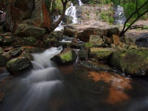
Around a corner, there are more fine views, across a wooded valley, with the Chinese landscaped garden, Lung Tsai Ng Yuen, just above a waterfall, surrounded by hills. The trail leads right by Ng Yuen. It’s normally closed, but you can stand on a small dam and admire the carp pond and zigzag bridge (and maybe toss some bread to the fish). Maybe you’ll be lucky and find it open; if so, it’s a splendid place to look around – for some photos and a little info, see my page on Lung Tsai Ng Yuen.
 There are steps uphill from here, to the crest of a small ridge near Man Cheung Po. Here, there’s a trail junction. You could turn left for a short cut towards Sham Wat Road. Or, straight on and down a little is Man Cheung Po.
Man Cheung Po is like a basin ringed by hills, with a stream tumbling through a wooded valley. There’s a campsite here; but no buildings (I’ve noticed) other than a small temple, a little higher to the south.
The trail climbs past this temple. Look left, and you should see the Flying Dragon statue, atop a boulder.
More climbing, and you’re in a wild landscape, with scrub and grassland, rolling hills, and the South China Sea below. The Lantau Trail now follows a switchback ridge of hills above the coast.
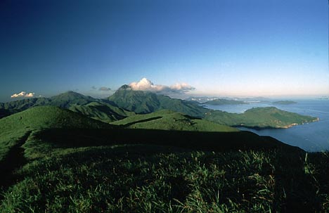
You climb to the top of the highest peak in southwest Lantau, 490-metre Ling Wui Shan, a top spot for a rest and a drink, and for savouring the splendid isolation and magnificent scenery. From here on an extremely clear summer day (when I took the photo), I’ve seen north to Shekou in Shenzhen, west to Macau, and east to Hong Kong Island, as well as south over islands including the Sokos in Hong Kong, and islands belonging to Zhuhai.
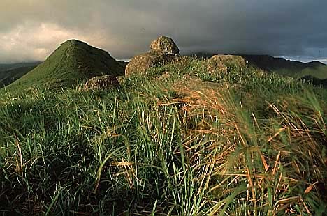
Continuing from Ling Wui Shan, the views remain scintillating on smog free days. Even on more typical days with some smog the views are decent (as just below; taken in autumn, when grass is yellowed from dry weather).
 There’s a gentler stretch, with junctions with a couple of trails: the short cut from near Man Cheung Po, and a trail down to a catchment above the coast – which should provide an easier and shorter way back to the main road if you can’t face more hill climbs – and to a country trail along the hillside below (I tried this once; don’t really recommend).
Gentler stretch over, there’s another hill climb, then sown and up to another peak. After which – woah! – the trail plunges down into a steep gully, then leaps up again.
 And that’s almost it. You’re on the last of the hills, Kwun Yam Shan, and can peer down to the temple below, as well as survey the scenery; Shek Pik Reservoir is down to the east. From here, the trail drops down flights of rock steps, to the main road, and bus stops.
You can head to the water catchwater at the start of the route by taking bus 1 to Tai O from Mui Wo ferry pier (or bus from Tung Chung to Tai O). The catchwater stop is fairly soon after the junction with the road to Ngong Ping and the Big Buddha (on the right). Watch for the Kwun Yam Temple on the left; it’s just visible for a short time, and there’s a road to it through an archway – the stop you want is right after this. From the bus stop at the end of the route, you can catch buses that have come from Tai O and Ngong Ping.